Skrwilno geodata
Skrwilno (Kujawsko-Pomorskie) is a seat of a third-order administrative division; located in Poland in Europe/Warsaw (GMT+2) time zone. With population of 1,624 people, there are 1737 cities with bigger population in this country. Compared to other cities in Poland, 83.8% of cities are located further ↓South; 51.3% of cities are located further ←West and 70.4% of cities have higher elevation than Skrwilno. Note1


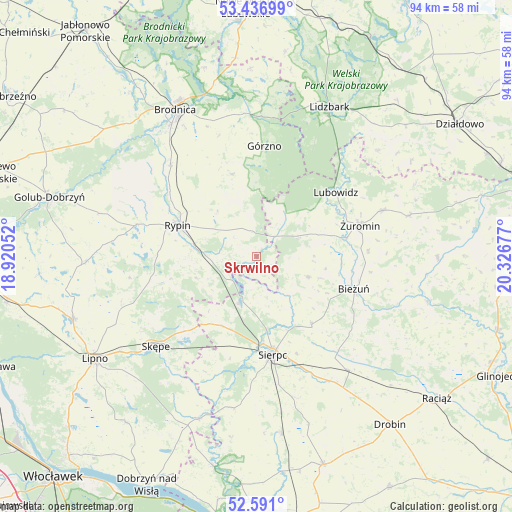
Skrwilno GPS coordinates[2]
53° 0' 57.852" North, 19° 37' 25.104" East
| Map corner | latitude | longitude |
|---|---|---|
| Upper-left | 53.43699°, | 18.92052° |
| Center: | 53.01607°, | 19.62364° |
| Lower-right: | 52.591°, | 20.32677° |
| Map W x H: | 94.1×94.1 km | = 58.5×58.5mi |
| max Lat: | 54.83135° ⇑16.2% North |
| Skrwilno: | 53.01607° |
| min Lat: | ⇓83.8% South 49.21328° |
| min Long | Skrwilno | max Long |
| 14.20249° | 19.62364° | 24.03723° |
| W 51.3%⇐ | ⇒48.7% E |
Elevation
Elevation of Skrwilno is 120 m = 394 ft, and this is 71.4 m = 234 ft below average elevation for this country.
| Max E: |
974 m = 3196 ft | 70.4% |
| Avg. | 191.4 m = 628 ft | |
| Skrwilno | 120 m = 394 ft | |
Min E: |
-3 m = -10 ft | 29.6% |
See also: Poland elevation on elevation.city.
Geographical zone
Skrwilno is located in North temperate zone (between Tropic of Cancer and the Arctic Circle). Distance of this North polar circle is 1506.3 km =936 mi to North.| Distance of | km | miles | from Skrwilno |
|---|---|---|---|
| North Pole | 4112.2 | 2555.2 | to North |
| Arctic Circle | 1506.3 | 936 | to North |
| Tropic Cancer | 3288.9 | 2043.6 | to South |
| Equator | 5894.8 | 3662.9 | to South |


Nearby cities:
15 places around Skrwilno: (largest is in red/bold)
• Bieżuń
18.8 km =11.7 mi,  108°
108°
• Górzno
20.2 km =12.6 mi,  3°
3°
• Janowo
14.3 km =8.9 mi,  347°
347°
• Lubowidz
18.7 km =11.6 mi,  52°
52°
• Lutocin
10.3 km =6.4 mi, 111°
• Osiek
23.3 km =14.5 mi,  317°
317°
• Ostrowite
22.9 km =14.2 mi,  284°
284°
• Rogowo
16.6 km =10.3 mi,  254°
254°
• Rościszewo
16.1 km =10 mi,  141°
141°
• Rypin
15.4 km =9.6 mi,  291°
291°
• Sierpc
18 km =11.2 mi,  170°
170°
• Skępe
24.3 km =15.1 mi,  227°
227°
• Szczutowo
9 km =5.6 mi,  201°
201°
• Świedziebnia
15.8 km =9.8 mi,  343°
343°
• Żuromin
19.9 km =12.4 mi,  73°
73°
Sources, notices
• [Note1] Compared only with cities in Poland existing in our database
• [Src1] Map data: © OpenStreetMap contributors (CC-BY-SA)
• [Src2] Other city data from geonames.org with taken over terms of usage.
• [Src3] Geographical zone / Annual Mean Temperature by Robert A. Rohde @ Wikipedia
