Rogowo geodata
Rogowo (Kujawsko-Pomorskie) is a seat of a third-order administrative division; located in Poland in Europe/Warsaw (GMT+2) time zone. With population of 540 people, there are 3429 cities with bigger population in this country. Compared to other cities in Poland, 83.3% of cities are located further ↓South; 53% of cities are located further →East and 66.4% of cities have higher elevation than Rogowo. Note1


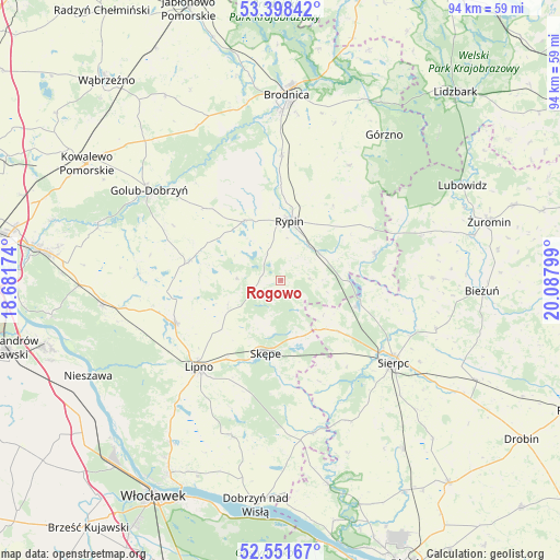
Rogowo GPS coordinates[2]
52° 58' 37.632" North, 19° 23' 5.496" East
| Map corner | latitude | longitude |
|---|---|---|
| Upper-left | 53.39842°, | 18.68174° |
| Center: | 52.97712°, | 19.38486° |
| Lower-right: | 52.55167°, | 20.08799° |
| Map W x H: | 94.1×94.1 km | = 58.5×58.5mi |
| max Lat: | 54.83135° ⇑16.7% North |
| Rogowo: | 52.97712° |
| min Lat: | ⇓83.3% South 49.21328° |
| min Long | Rogowo | max Long |
| 14.20249° | 19.38486° | 24.03723° |
| W 47%⇐ | ⇒53% E |
Elevation
Elevation of Rogowo is 129 m = 423 ft, and this is 62.4 m = 205 ft below average elevation for this country.
| Max E: |
974 m = 3196 ft | 66.4% |
| Avg. | 191.4 m = 628 ft | |
| Rogowo | 129 m = 423 ft | |
Min E: |
-3 m = -10 ft | 33.6% |
See also: Poland elevation on elevation.city.
Geographical zone
Rogowo is located in North temperate zone (between Tropic of Cancer and the Arctic Circle). Distance of this North polar circle is 1510.7 km =938.7 mi to North.| Distance of | km | miles | from Rogowo |
|---|---|---|---|
| North Pole | 4116.6 | 2557.9 | to North |
| Arctic Circle | 1510.7 | 938.7 | to North |
| Tropic Cancer | 3284.6 | 2041 | to South |
| Equator | 5890.5 | 3660.2 | to South |


Nearby cities:
15 places around Rogowo: (largest is in red/bold)
• Brzuze
11.9 km =7.4 mi,  316°
316°
• Chrostkowo
9.6 km =6 mi,  247°
247°
• Kikół
19.2 km =11.9 mi, 247°
• Lipno
20.2 km =12.6 mi,  223°
223°
• Lubin
19 km =11.8 mi,  256°
256°
• Osiek
21.4 km =13.3 mi,  0°
0°
• Ostrowite
11.9 km =7.4 mi,  329°
329°
• Radomin
17.6 km =10.9 mi,  313°
313°
• Rypin
10 km =6.2 mi,  9°
9°
• Skrwilno
16.6 km =10.3 mi,  74°
74°
• Skępe
12.3 km =7.6 mi,  189°
189°
• Szczutowo
13.3 km =8.3 mi,  107°
107°
• Wielgie
19.2 km =11.9 mi,  278°
278°
• Wąpielsk
19.2 km =11.9 mi,  338°
338°
• Zbójno
15.6 km =9.7 mi, 282°
Sources, notices
• [Note1] Compared only with cities in Poland existing in our database
• [Src1] Map data: © OpenStreetMap contributors (CC-BY-SA)
• [Src2] Other city data from geonames.org with taken over terms of usage.
• [Src3] Geographical zone / Annual Mean Temperature by Robert A. Rohde @ Wikipedia
