Lidzbark geodata
Lidzbark (Warmia-Masuria) is a seat of a third-order administrative division; located in Poland in Europe/Warsaw (GMT+2) time zone. With population of 8,177 people, there are 502 cities with bigger population in this country. Compared to other cities in Poland, 87.1% of cities are located further ↓South; 55.4% of cities are located further ←West and 64.7% of cities have higher elevation than Lidzbark. Note1


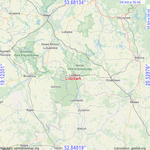
Lidzbark GPS coordinates[2]
53° 15' 46.188" North, 19° 49' 35.868" East
| Map corner | latitude | longitude |
|---|---|---|
| Upper-left | 53.68134°, | 19.12351° |
| Center: | 53.26283°, | 19.82663° |
| Lower-right: | 52.84019°, | 20.52976° |
| Map W x H: | 93.5×93.5 km | = 58.1×58.1mi |
| max Lat: | 54.83135° ⇑12.9% North |
| Lidzbark: | 53.26283° |
| min Lat: | ⇓87.1% South 49.21328° |
| min Long | Lidzbark | max Long |
| 14.20249° | 19.82663° | 24.03723° |
| W 55.4%⇐ | ⇒44.6% E |
Elevation
Elevation of Lidzbark is 134 m = 440 ft, and this is 57.4 m = 188 ft below average elevation for this country.
| Max E: |
974 m = 3196 ft | 64.7% |
| Avg. | 191.4 m = 628 ft | |
| Lidzbark | 134 m = 440 ft | |
Min E: |
-3 m = -10 ft | 35.3% |
See also: Poland elevation on elevation.city.
Geographical zone
Lidzbark is located in North temperate zone (between Tropic of Cancer and the Arctic Circle). Distance of this North polar circle is 1478.9 km =918.9 mi to North.| Distance of | km | miles | from Lidzbark |
|---|---|---|---|
| North Pole | 4084.8 | 2538.2 | to North |
| Arctic Circle | 1478.9 | 918.9 | to North |
| Tropic Cancer | 3316.4 | 2060.7 | to South |
| Equator | 5922.3 | 3679.9 | to South |


Nearby cities:
15 places around Lidzbark: (largest is in red/bold)
• Bartniczka
14.9 km =9.3 mi,  263°
263°
• Brzozie
16.3 km =10.1 mi,  295°
295°
• Brzozie Lubawskie
19.6 km =12.2 mi, 297°
• Działdowo
23 km =14.3 mi,  96°
96°
• Dąbrówno
23.5 km =14.6 mi,  36°
36°
• Grodziczno
17.3 km =10.7 mi,  345°
345°
• Górzno
14.2 km =8.8 mi,  239°
239°
• Janowo
21.3 km =13.2 mi,  230°
230°
• Kurzętnik
22.3 km =13.9 mi,  312°
312°
• Lubowidz
16.1 km =10 mi,  175°
175°
• Nowe Miasto Lubawskie
23.3 km =14.5 mi,  318°
318°
• Płośnica
12.3 km =7.6 mi,  85°
85°
• Rybno
15.1 km =9.4 mi,  27°
27°
• Świedziebnia
21.9 km =13.6 mi, 235°
• Żuromin
22.6 km =14 mi,  165°
165°
Sources, notices
• [Note1] Compared only with cities in Poland existing in our database
• [Src1] Map data: © OpenStreetMap contributors (CC-BY-SA)
• [Src2] Other city data from geonames.org with taken over terms of usage.
• [Src3] Geographical zone / Annual Mean Temperature by Robert A. Rohde @ Wikipedia
