Wąpielsk geodata
Wąpielsk (Kujawsko-Pomorskie) is a seat of a third-order administrative division; located in Poland in Europe/Warsaw (GMT+2) time zone. With population of 803 people, there are 2848 cities with bigger population in this country. Compared to other cities in Poland, 85.4% of cities are located further ↓South; 54.6% of cities are located further →East and 79.3% of cities have higher elevation than Wąpielsk. Note1


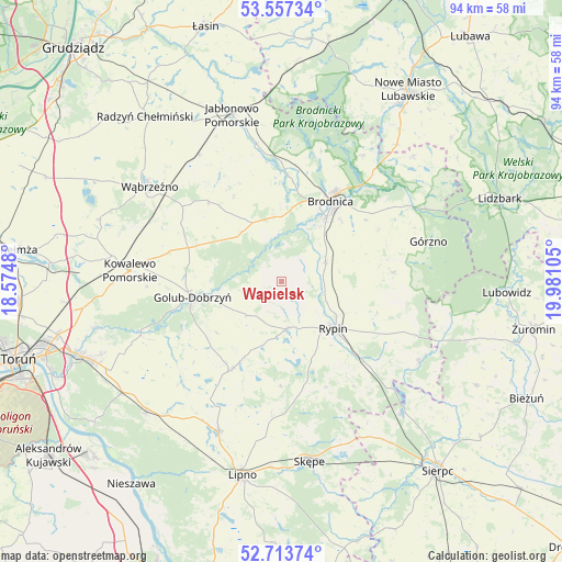
Wąpielsk GPS coordinates[2]
53° 8' 15.396" North, 19° 16' 40.512" East
| Map corner | latitude | longitude |
|---|---|---|
| Upper-left | 53.55734°, | 18.5748° |
| Center: | 53.13761°, | 19.27792° |
| Lower-right: | 52.71374°, | 19.98105° |
| Map W x H: | 93.8×93.8 km | = 58.3×58.3mi |
| max Lat: | 54.83135° ⇑14.6% North |
| Wąpielsk: | 53.13761° |
| min Lat: | ⇓85.4% South 49.21328° |
| min Long | Wąpielsk | max Long |
| 14.20249° | 19.27792° | 24.03723° |
| W 45.4%⇐ | ⇒54.6% E |
Elevation
Elevation of Wąpielsk is 101 m = 331 ft, and this is 90.4 m = 297 ft below average elevation for this country.
| Max E: |
974 m = 3196 ft | 79.3% |
| Avg. | 191.4 m = 628 ft | |
| Wąpielsk | 101 m = 331 ft | |
Min E: |
-3 m = -10 ft | 20.7% |
See also: Poland elevation on elevation.city.
Geographical zone
Wąpielsk is located in North temperate zone (between Tropic of Cancer and the Arctic Circle). Distance of this North polar circle is 1492.8 km =927.6 mi to North.| Distance of | km | miles | from Wąpielsk |
|---|---|---|---|
| North Pole | 4098.7 | 2546.8 | to North |
| Arctic Circle | 1492.8 | 927.6 | to North |
| Tropic Cancer | 3302.4 | 2052 | to South |
| Equator | 5908.3 | 3671.2 | to South |


Nearby cities:
15 places around Wąpielsk: (largest is in red/bold)
• Bobrowo
16.5 km =10.3 mi,  358°
358°
• Brodnica
15.7 km =9.8 mi,  30°
30°
• Brzuze
9.3 km =5.8 mi,  186°
186°
• Dębowa Łąka
17.8 km =11.1 mi,  317°
317°
• Golub-Dobrzyń
15.2 km =9.4 mi,  258°
258°
• Lisewo
14 km =8.7 mi,  275°
275°
• Osiek
8 km =5 mi,  64°
64°
• Ostrowite
7.7 km =4.8 mi,  172°
172°
• Ostrowite
19.6 km =12.2 mi,  271°
271°
• Radomin
8 km =5 mi,  224°
224°
• Rogowo
19.2 km =11.9 mi,  158°
158°
• Rypin
11.8 km =7.3 mi,  132°
132°
• Wielgie
19.1 km =11.9 mi, 218°
• Zbójno
16.5 km =10.3 mi,  209°
209°
• Świedziebnia
18.5 km =11.5 mi,  85°
85°
Sources, notices
• [Note1] Compared only with cities in Poland existing in our database
• [Src1] Map data: © OpenStreetMap contributors (CC-BY-SA)
• [Src2] Other city data from geonames.org with taken over terms of usage.
• [Src3] Geographical zone / Annual Mean Temperature by Robert A. Rohde @ Wikipedia
