Lubliniec geodata
Lubliniec (Silesia) is a populated place; located in Poland in Europe/Warsaw (GMT+2) time zone. With population of 24,133 people, there are 200 cities with bigger population in this country. Compared to other cities in Poland, 63.4% of cities are located further ↑North; 65.3% of cities are located further →East and 78.1% of cities have lower elevation than Lubliniec. Note1


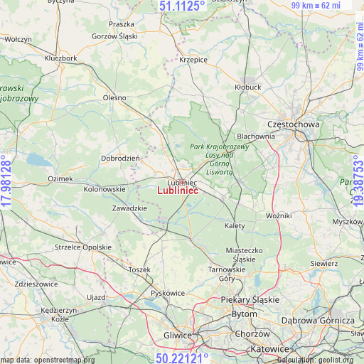
Lubliniec GPS coordinates[2]
50° 40' 8.292" North, 18° 41' 3.84" East
| Map corner | latitude | longitude |
|---|---|---|
| Upper-left | 51.1125°, | 17.98128° |
| Center: | 50.66897°, | 18.6844° |
| Lower-right: | 50.22121°, | 19.38753° |
| Map W x H: | 99.1×99.1 km | = 61.6×61.6mi |
| max Lat: | 54.83135° ⇑63.4% North |
| Lubliniec: | 50.66897° |
| min Lat: | ⇓36.6% South 49.21328° |
| min Long | Lubliniec | max Long |
| 14.20249° | 18.6844° | 24.03723° |
| W 34.7%⇐ | ⇒65.3% E |
Elevation
Elevation of Lubliniec is 258 m = 846 ft, and this is 66.6 m = 219 ft above average elevation for this country.
| Max E: |
974 m = 3196 ft | 21.9% |
| Lubliniec | 258 m 846 ft | |
| Avg. | 191.4 m = 628 ft | |
Min E: |
-3 m = -10 ft | 78.1% |
See also: Poland elevation on elevation.city.
Geographical zone
Lubliniec is located in North temperate zone (between Tropic of Cancer and the Arctic Circle). Distance of this North polar circle is 1767.3 km =1098.1 mi to North.| Distance of | km | miles | from Lubliniec |
|---|---|---|---|
| North Pole | 4373.2 | 2717.4 | to North |
| Arctic Circle | 1767.3 | 1098.1 | to North |
| Tropic Cancer | 3027.9 | 1881.4 | to South |
| Equator | 5633.9 | 3500.7 | to South |


Nearby cities:
15 places around Lubliniec: (largest is in red/bold)
• Boronów
15.7 km =9.8 mi,  87°
87°
• Ciasna
10.9 km =6.8 mi,  330°
330°
• Dobrodzień
18.1 km =11.2 mi,  291°
291°
• Gwoździany
12.4 km =7.7 mi,  298°
298°
• Herby
17.1 km =10.6 mi,  56°
56°
• Kalety
18.9 km =11.7 mi,  128°
128°
• Kochanowice
6.1 km =3.8 mi,  48°
48°
• Koszęcin
11.7 km =7.3 mi,  109°
109°
• Krupski Młyn
11.5 km =7.1 mi,  202°
202°
• Pawonków
7.8 km =4.8 mi, 291°
• Sieraków Śląski
16.7 km =10.4 mi, 332°
• Strzebiń
16.1 km =10 mi, 111°
• Tworóg
15.5 km =9.6 mi,  171°
171°
• Wielowieś
18.4 km =11.4 mi, 195°
• Zawadzkie
15.8 km =9.8 mi,  243°
243°
Sources, notices
• [Note1] Compared only with cities in Poland existing in our database
• [Src1] Map data: © OpenStreetMap contributors (CC-BY-SA)
• [Src2] Other city data from geonames.org with taken over terms of usage.
• [Src3] Geographical zone / Annual Mean Temperature by Robert A. Rohde @ Wikipedia
