Kochanowice geodata
Kochanowice (Silesia) is a populated place; located in Poland in Europe/Warsaw (GMT+2) time zone. With population of 1,944 people, there are 1521 cities with bigger population in this country. Compared to other cities in Poland, 62.5% of cities are located further ↑North; 64.3% of cities are located further →East and 81.9% of cities have lower elevation than Kochanowice. Note1


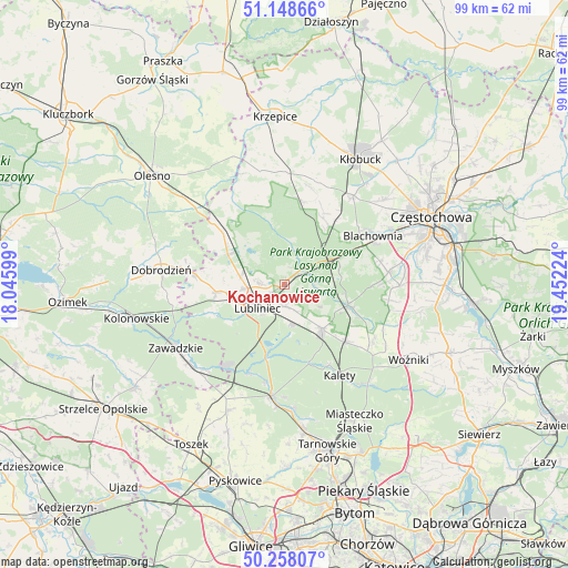
Kochanowice GPS coordinates[2]
50° 42' 19.728" North, 18° 44' 56.796" East
| Map corner | latitude | longitude |
|---|---|---|
| Upper-left | 51.14866°, | 18.04599° |
| Center: | 50.70548°, | 18.74911° |
| Lower-right: | 50.25807°, | 19.45224° |
| Map W x H: | 99×99 km | = 61.5×61.5mi |
| max Lat: | 54.83135° ⇑62.5% North |
| Kochanowice: | 50.70548° |
| min Lat: | ⇓37.5% South 49.21328° |
| min Long | Kochanowice | max Long |
| 14.20249° | 18.74911° | 24.03723° |
| W 35.7%⇐ | ⇒64.3% E |
Elevation
Elevation of Kochanowice is 275 m = 902 ft, and this is 83.6 m = 274 ft above average elevation for this country.
| Max E: |
974 m = 3196 ft | 18.1% |
| Kochanowice | 275 m 902 ft | |
| Avg. | 191.4 m = 628 ft | |
Min E: |
-3 m = -10 ft | 81.9% |
See also: Poland elevation on elevation.city.
Geographical zone
Kochanowice is located in North temperate zone (between Tropic of Cancer and the Arctic Circle). Distance of this North polar circle is 1763.3 km =1095.7 mi to North.| Distance of | km | miles | from Kochanowice |
|---|---|---|---|
| North Pole | 4369.1 | 2714.8 | to North |
| Arctic Circle | 1763.3 | 1095.7 | to North |
| Tropic Cancer | 3032 | 1884 | to South |
| Equator | 5637.9 | 3503.2 | to South |


Nearby cities:
15 places around Kochanowice: (largest is in red/bold)
• Blachownia
17.2 km =10.7 mi,  61°
61°
• Boronów
11.6 km =7.2 mi,  107°
107°
• Ciasna
11.3 km =7 mi,  298°
298°
• Gwoździany
15.6 km =9.7 mi,  276°
276°
• Herby
11.1 km =6.9 mi, 61°
• Kalety
18.8 km =11.7 mi,  147°
147°
• Konopiska
18.4 km =11.4 mi,  82°
82°
• Koszęcin
10.3 km =6.4 mi,  140°
140°
• Krupski Młyn
17.2 km =10.7 mi,  211°
211°
• Lubliniec
6.1 km =3.8 mi,  228°
228°
• Pawonków
11.9 km =7.4 mi,  264°
264°
• Psary
18.5 km =11.5 mi,  122°
122°
• Sieraków Śląski
16.3 km =10.1 mi,  311°
311°
• Strzebiń
14.4 km =8.9 mi,  133°
133°
• Truskolasy
18.8 km =11.7 mi,  16°
16°
Sources, notices
• [Note1] Compared only with cities in Poland existing in our database
• [Src1] Map data: © OpenStreetMap contributors (CC-BY-SA)
• [Src2] Other city data from geonames.org with taken over terms of usage.
• [Src3] Geographical zone / Annual Mean Temperature by Robert A. Rohde @ Wikipedia
