Boczów geodata
Boczów (Lubusz) is a populated place; located in Poland in Europe/Warsaw (GMT+2) time zone. With population of 675 people, there are 3122 cities with bigger population in this country. Compared to other cities in Poland, 73.1% of cities are located further ↓South; 98.4% of cities are located further →East and 86.8% of cities have higher elevation than Boczów. Note1


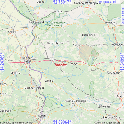
Boczów GPS coordinates[2]
52° 19' 20.964" North, 14° 56' 48.516" East
| Map corner | latitude | longitude |
|---|---|---|
| Upper-left | 52.75017°, | 14.24369° |
| Center: | 52.32249°, | 14.94681° |
| Lower-right: | 51.89064°, | 15.64994° |
| Map W x H: | 95.6×95.6 km | = 59.4×59.4mi |
| max Lat: | 54.83135° ⇑26.9% North |
| Boczów: | 52.32249° |
| min Lat: | ⇓73.1% South 49.21328° |
| min Long | Boczów | max Long |
| 14.20249° | 14.94681° | 24.03723° |
| W 1.6%⇐ | ⇒98.4% E |
Elevation
Elevation of Boczów is 85 m = 279 ft, and this is 106.4 m = 349 ft below average elevation for this country.
| Max E: |
974 m = 3196 ft | 86.8% |
| Avg. | 191.4 m = 628 ft | |
| Boczów | 85 m = 279 ft | |
Min E: |
-3 m = -10 ft | 13.2% |
See also: Poland elevation on elevation.city.
Geographical zone
Boczów is located in North temperate zone (between Tropic of Cancer and the Arctic Circle). Distance of this North polar circle is 1583.5 km =983.9 mi to North.| Distance of | km | miles | from Boczów |
|---|---|---|---|
| North Pole | 4189.3 | 2603.1 | to North |
| Arctic Circle | 1583.5 | 983.9 | to North |
| Tropic Cancer | 3211.8 | 1995.7 | to South |
| Equator | 5817.7 | 3615 | to South |


Nearby cities:
15 places around Boczów: (largest is in red/bold)
• Bytnica
24.4 km =15.2 mi,  141°
141°
• Cybinka
17.6 km =10.9 mi,  215°
215°
• Glisno
26.3 km =16.3 mi,  49°
49°
• Górzyca
27.5 km =17.1 mi,  314°
314°
• Krzeszyce
29.3 km =18.2 mi,  8°
8°
• Lemierzyce
27.3 km =17 mi,  355°
355°
• Maszewo
28.3 km =17.6 mi,  185°
185°
• Osiecznica
28.2 km =17.5 mi,  165°
165°
• Ośno Lubuskie
15.4 km =9.6 mi,  341°
341°
• Rzepin
8.2 km =5.1 mi,  288°
288°
• Sulęcin
17.8 km =11.1 mi,  40°
40°
• Słońsk
28.5 km =17.7 mi, 340°
• Słubice
26.4 km =16.4 mi,  276°
276°
• Torzym
9.3 km =5.8 mi,  96°
96°
• Łagów
23.9 km =14.9 mi,  86°
86°
Sources, notices
• [Note1] Compared only with cities in Poland existing in our database
• [Src1] Map data: © OpenStreetMap contributors (CC-BY-SA)
• [Src2] Other city data from geonames.org with taken over terms of usage.
• [Src3] Geographical zone / Annual Mean Temperature by Robert A. Rohde @ Wikipedia
