Duszniki-Zdrój geodata
Duszniki-Zdrój (Lower Silesia) is a seat of a third-order administrative division; located in Poland in Europe/Warsaw (GMT+2) time zone. With population of 4,888 people, there are 700 cities with bigger population in this country. Compared to other cities in Poland, 69.4% of cities are located further ↑North; 90.2% of cities are located further →East and 97.9% of cities have lower elevation than Duszniki-Zdrój. Note1


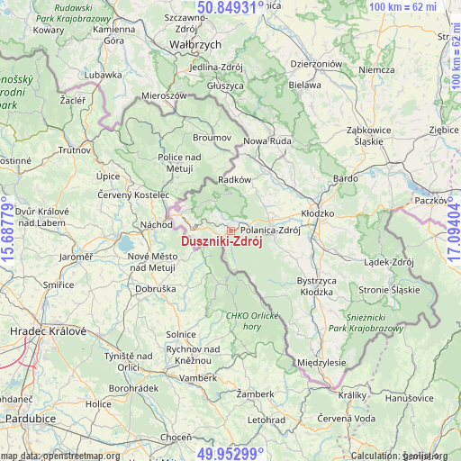
Duszniki-Zdrój GPS coordinates[2]
50° 24' 11.772" North, 16° 23' 27.276" East
| Map corner | latitude | longitude |
|---|---|---|
| Upper-left | 50.84931°, | 15.68779° |
| Center: | 50.40327°, | 16.39091° |
| Lower-right: | 49.95299°, | 17.09404° |
| Map W x H: | 99.7×99.7 km | = 62×62mi |
| max Lat: | 54.83135° ⇑69.4% North |
| Duszniki-Zdrój: | 50.40327° |
| min Lat: | ⇓30.6% South 49.21328° |
| min Long | Duszniki-Zdrój | max Long |
| 14.20249° | 16.39091° | 24.03723° |
| W 9.8%⇐ | ⇒90.2% E |
Elevation
Elevation of Duszniki-Zdrój is 529 m = 1736 ft, and this is 337.6 m = 1108 ft above average elevation for this country.
| Max E: |
974 m = 3196 ft | 2.1% |
| Duszniki-Zdrój | 529 m 1736 ft | |
| Avg. | 191.4 m = 628 ft | |
Min E: |
-3 m = -10 ft | 97.9% |
See also: Poland elevation on elevation.city.
Geographical zone
Duszniki-Zdrój is located in North temperate zone (between Tropic of Cancer and the Arctic Circle). Distance of this North polar circle is 1796.9 km =1116.5 mi to North.| Distance of | km | miles | from Duszniki-Zdrój |
|---|---|---|---|
| North Pole | 4402.7 | 2735.7 | to North |
| Arctic Circle | 1796.9 | 1116.5 | to North |
| Tropic Cancer | 2998.4 | 1863.1 | to South |
| Equator | 5604.3 | 3482.3 | to South |


Nearby cities:
15 places around Duszniki-Zdrój: (largest is in red/bold)
• Bardo
27.2 km =16.9 mi,  65°
65°
• Bierkowice
16.9 km =10.5 mi,  62°
62°
• Bozkow
17.9 km =11.1 mi,  46°
46°
• Bystrzyca Kłodzka
21.1 km =13.1 mi,  122°
122°
• Jugów
26.5 km =16.5 mi,  19°
19°
• Kudowa-Zdrój
11.3 km =7 mi,  292°
292°
• Kłodzko
19.5 km =12.1 mi,  79°
79°
• Lewin Kłodzki
7.1 km =4.4 mi,  272°
272°
• Ludwikowice Kłodzkie
25.1 km =15.6 mi,  11°
11°
• Nowa Ruda
21.2 km =13.2 mi, 21°
• Polanica-Zdrój
8.6 km =5.3 mi,  89°
89°
• Radków
11.3 km =7 mi,  3°
3°
• Szczytna
4.2 km =2.6 mi, 74°
• Wojciechowice
23 km =14.3 mi, 75°
• Włodowice
20.1 km =12.5 mi, 17°
Sources, notices
• [Note1] Compared only with cities in Poland existing in our database
• [Src1] Map data: © OpenStreetMap contributors (CC-BY-SA)
• [Src2] Other city data from geonames.org with taken over terms of usage.
• [Src3] Geographical zone / Annual Mean Temperature by Robert A. Rohde @ Wikipedia
