Bozkow geodata
Bozkow (Lower Silesia) is a populated place; located in Poland in Europe/Warsaw (GMT+2) time zone. With population of 1,600 people, there are 1751 cities with bigger population in this country. Compared to other cities in Poland, 67.1% of cities are located further ↑North; 89% of cities are located further →East and 91.8% of cities have lower elevation than Bozkow. Note1


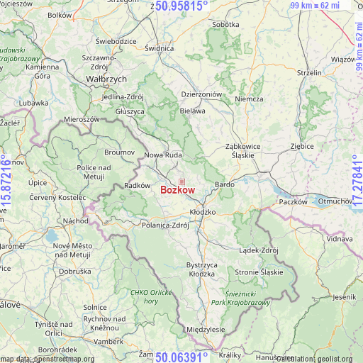
Bozkow GPS coordinates[2]
50° 30' 47.34" North, 16° 34' 31.008" East
| Map corner | latitude | longitude |
|---|---|---|
| Upper-left | 50.95815°, | 15.87216° |
| Center: | 50.51315°, | 16.57528° |
| Lower-right: | 50.06391°, | 17.27841° |
| Map W x H: | 99.4×99.4 km | = 61.8×61.8mi |
| max Lat: | 54.83135° ⇑67.1% North |
| Bozkow: | 50.51315° |
| min Lat: | ⇓32.9% South 49.21328° |
| min Long | Bozkow | max Long |
| 14.20249° | 16.57528° | 24.03723° |
| W 11%⇐ | ⇒89% E |
Elevation
Elevation of Bozkow is 352 m = 1155 ft, and this is 160.6 m = 527 ft above average elevation for this country.
| Max E: |
974 m = 3196 ft | 8.2% |
| Bozkow | 352 m 1155 ft | |
| Avg. | 191.4 m = 628 ft | |
Min E: |
-3 m = -10 ft | 91.8% |
See also: Poland elevation on elevation.city.
Geographical zone
Bozkow is located in North temperate zone (between Tropic of Cancer and the Arctic Circle). Distance of this North polar circle is 1784.6 km =1108.9 mi to North.| Distance of | km | miles | from Bozkow |
|---|---|---|---|
| North Pole | 4390.5 | 2728.1 | to North |
| Arctic Circle | 1784.6 | 1108.9 | to North |
| Tropic Cancer | 3010.6 | 1870.7 | to South |
| Equator | 5616.5 | 3489.9 | to South |


Nearby cities:
15 places around Bozkow: (largest is in red/bold)
• Bardo
11.7 km =7.3 mi,  93°
93°
• Bierkowice
4.7 km =2.9 mi,  156°
156°
• Brzeźnica
11.5 km =7.1 mi,  74°
74°
• Budzów
13.1 km =8.1 mi,  46°
46°
• Jodłownik
15 km =9.3 mi,  10°
10°
• Jugów
13.3 km =8.3 mi,  342°
342°
• Kłodzko
10.6 km =6.6 mi,  144°
144°
• Ludwikowice Kłodzkie
14.8 km =9.2 mi,  326°
326°
• Nowa Ruda
9.1 km =5.7 mi, 325°
• Polanica-Zdrój
12.9 km =8 mi,  200°
200°
• Przyłęk
14.4 km =8.9 mi, 87°
• Radków
12.4 km =7.7 mi,  265°
265°
• Szczytna
14.3 km =8.9 mi,  219°
219°
• Wojciechowice
11.3 km =7 mi,  125°
125°
• Włodowice
9.8 km =6.1 mi,  314°
314°
Sources, notices
• [Note1] Compared only with cities in Poland existing in our database
• [Src1] Map data: © OpenStreetMap contributors (CC-BY-SA)
• [Src2] Other city data from geonames.org with taken over terms of usage.
• [Src3] Geographical zone / Annual Mean Temperature by Robert A. Rohde @ Wikipedia
