Nowa Ruda geodata
Nowa Ruda (Lower Silesia) is a populated place; located in Poland in Europe/Warsaw (GMT+2) time zone. With population of 24,753 people, there are 196 cities with bigger population in this country. Compared to other cities in Poland, 65.6% of cities are located further ↑North; 89.5% of cities are located further →East and 94.1% of cities have lower elevation than Nowa Ruda. Note1


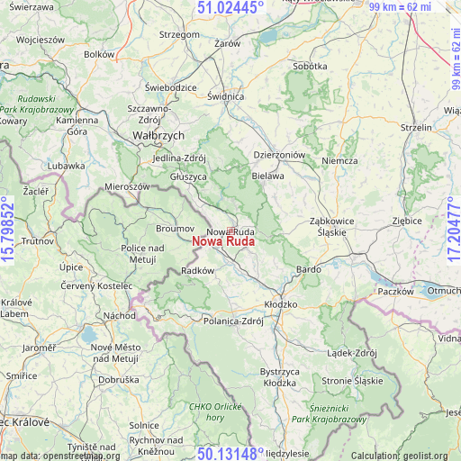
Nowa Ruda GPS coordinates[2]
50° 34' 48.288" North, 16° 30' 5.904" East
| Map corner | latitude | longitude |
|---|---|---|
| Upper-left | 51.02445°, | 15.79852° |
| Center: | 50.58008°, | 16.50164° |
| Lower-right: | 50.13148°, | 17.20477° |
| Map W x H: | 99.3×99.3 km | = 61.7×61.7mi |
| max Lat: | 54.83135° ⇑65.6% North |
| Nowa Ruda: | 50.58008° |
| min Lat: | ⇓34.4% South 49.21328° |
| min Long | Nowa Ruda | max Long |
| 14.20249° | 16.50164° | 24.03723° |
| W 10.5%⇐ | ⇒89.5% E |
Elevation
Elevation of Nowa Ruda is 392 m = 1286 ft, and this is 200.6 m = 658 ft above average elevation for this country.
| Max E: |
974 m = 3196 ft | 5.9% |
| Nowa Ruda | 392 m 1286 ft | |
| Avg. | 191.4 m = 628 ft | |
Min E: |
-3 m = -10 ft | 94.1% |
See also: Poland elevation on elevation.city.
Geographical zone
Nowa Ruda is located in North temperate zone (between Tropic of Cancer and the Arctic Circle). Distance of this North polar circle is 1777.2 km =1104.3 mi to North.| Distance of | km | miles | from Nowa Ruda |
|---|---|---|---|
| North Pole | 4383.1 | 2723.5 | to North |
| Arctic Circle | 1777.2 | 1104.3 | to North |
| Tropic Cancer | 3018.1 | 1875.4 | to South |
| Equator | 5624 | 3494.6 | to South |


Nearby cities:
15 places around Nowa Ruda: (largest is in red/bold)
• Bielawa
15 km =9.3 mi,  34°
34°
• Bierkowice
13.8 km =8.6 mi,  148°
148°
• Bozkow
9.1 km =5.7 mi, 145°
• Budzów
14.8 km =9.2 mi,  84°
84°
• Głuszyca
15 km =9.3 mi,  322°
322°
• Głuszyca Górna
13 km =8.1 mi, 317°
• Jodłownik
10.7 km =6.6 mi,  47°
47°
• Jugów
5.4 km =3.4 mi,  12°
12°
• Ludwikowice Kłodzkie
5.7 km =3.5 mi,  329°
329°
• Ostroszowice
12.2 km =7.6 mi, 53°
• Pieszyce
15.8 km =9.8 mi,  21°
21°
• Radków
11 km =6.8 mi,  220°
220°
• Stoszowice
16.9 km =10.5 mi, 82°
• Walim
13.7 km =8.5 mi,  342°
342°
• Włodowice
1.9 km =1.2 mi,  253°
253°
Sources, notices
• [Note1] Compared only with cities in Poland existing in our database
• [Src1] Map data: © OpenStreetMap contributors (CC-BY-SA)
• [Src2] Other city data from geonames.org with taken over terms of usage.
• [Src3] Geographical zone / Annual Mean Temperature by Robert A. Rohde @ Wikipedia
