Włodowice geodata
Włodowice (Lower Silesia) is a populated place; located in Poland in Europe/Warsaw (GMT+2) time zone. With population of 792 people, there are 2872 cities with bigger population in this country. Compared to other cities in Poland, 65.8% of cities are located further ↑North; 89.7% of cities are located further →East and 93.1% of cities have lower elevation than Włodowice. Note1


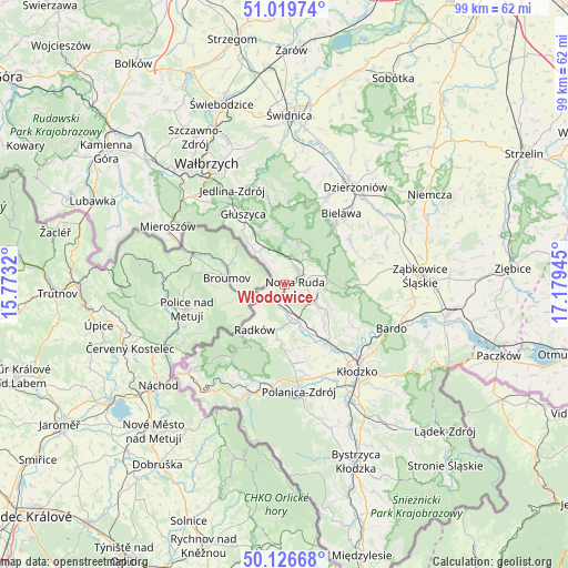
Włodowice GPS coordinates[2]
50° 34' 31.188" North, 16° 28' 34.752" East
| Map corner | latitude | longitude |
|---|---|---|
| Upper-left | 51.01974°, | 15.7732° |
| Center: | 50.57533°, | 16.47632° |
| Lower-right: | 50.12668°, | 17.17945° |
| Map W x H: | 99.3×99.3 km | = 61.7×61.7mi |
| max Lat: | 54.83135° ⇑65.8% North |
| Włodowice: | 50.57533° |
| min Lat: | ⇓34.2% South 49.21328° |
| min Long | Włodowice | max Long |
| 14.20249° | 16.47632° | 24.03723° |
| W 10.3%⇐ | ⇒89.7% E |
Elevation
Elevation of Włodowice is 371 m = 1217 ft, and this is 179.6 m = 589 ft above average elevation for this country.
| Max E: |
974 m = 3196 ft | 6.9% |
| Włodowice | 371 m 1217 ft | |
| Avg. | 191.4 m = 628 ft | |
Min E: |
-3 m = -10 ft | 93.1% |
See also: Poland elevation on elevation.city.
Geographical zone
Włodowice is located in North temperate zone (between Tropic of Cancer and the Arctic Circle). Distance of this North polar circle is 1777.7 km =1104.6 mi to North.| Distance of | km | miles | from Włodowice |
|---|---|---|---|
| North Pole | 4383.6 | 2723.8 | to North |
| Arctic Circle | 1777.7 | 1104.6 | to North |
| Tropic Cancer | 3017.5 | 1875 | to South |
| Equator | 5623.4 | 3494.2 | to South |


Nearby cities:
15 places around Włodowice: (largest is in red/bold)
• Bielawa
16.5 km =10.3 mi,  38°
38°
• Bierkowice
14.4 km =8.9 mi,  141°
141°
• Bozkow
9.8 km =6.1 mi,  134°
134°
• Budzów
16.6 km =10.3 mi,  83°
83°
• Głuszyca
14.5 km =9 mi,  329°
329°
• Głuszyca Górna
12.3 km =7.6 mi,  324°
324°
• Jodłownik
12.4 km =7.7 mi,  51°
51°
• Jugów
6.5 km =4 mi,  26°
26°
• Ludwikowice Kłodzkie
5.6 km =3.5 mi,  348°
348°
• Nowa Ruda
1.9 km =1.2 mi,  73°
73°
• Ostroszowice
13.9 km =8.6 mi,  55°
55°
• Pieszyce
17 km =10.6 mi, 26°
• Radków
9.5 km =5.9 mi,  214°
214°
• Szczytna
18.1 km =11.2 mi,  186°
186°
• Walim
13.8 km =8.6 mi, 350°
Sources, notices
• [Note1] Compared only with cities in Poland existing in our database
• [Src1] Map data: © OpenStreetMap contributors (CC-BY-SA)
• [Src2] Other city data from geonames.org with taken over terms of usage.
• [Src3] Geographical zone / Annual Mean Temperature by Robert A. Rohde @ Wikipedia
