Bardo geodata
Bardo (Lower Silesia) is a populated place; located in Poland in Europe/Warsaw (GMT+2) time zone. With population of 2,763 people, there are 1141 cities with bigger population in this country. Compared to other cities in Poland, 67.2% of cities are located further ↑North; 87.7% of cities are located further →East and 82.5% of cities have lower elevation than Bardo. Note1


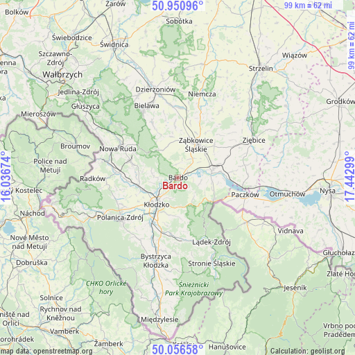
Bardo GPS coordinates[2]
50° 30' 21.204" North, 16° 44' 23.496" East
| Map corner | latitude | longitude |
|---|---|---|
| Upper-left | 50.95096°, | 16.03674° |
| Center: | 50.50589°, | 16.73986° |
| Lower-right: | 50.05658°, | 17.44299° |
| Map W x H: | 99.4×99.4 km | = 61.8×61.8mi |
| max Lat: | 54.83135° ⇑67.2% North |
| Bardo: | 50.50589° |
| min Lat: | ⇓32.8% South 49.21328° |
| min Long | Bardo | max Long |
| 14.20249° | 16.73986° | 24.03723° |
| W 12.3%⇐ | ⇒87.7% E |
Elevation
Elevation of Bardo is 278 m = 912 ft, and this is 86.6 m = 284 ft above average elevation for this country.
| Max E: |
974 m = 3196 ft | 17.5% |
| Bardo | 278 m 912 ft | |
| Avg. | 191.4 m = 628 ft | |
Min E: |
-3 m = -10 ft | 82.5% |
See also: Poland elevation on elevation.city.
Geographical zone
Bardo is located in North temperate zone (between Tropic of Cancer and the Arctic Circle). Distance of this North polar circle is 1785.4 km =1109.4 mi to North.| Distance of | km | miles | from Bardo |
|---|---|---|---|
| North Pole | 4391.3 | 2728.6 | to North |
| Arctic Circle | 1785.4 | 1109.4 | to North |
| Tropic Cancer | 3009.8 | 1870.2 | to South |
| Equator | 5615.7 | 3489.4 | to South |


Nearby cities:
15 places around Bardo: (largest is in red/bold)
• Bierkowice
10.4 km =6.5 mi,  250°
250°
• Bobolice
15.4 km =9.6 mi,  32°
32°
• Bozkow
11.7 km =7.3 mi,  273°
273°
• Brzeźnica
3.8 km =2.4 mi,  351°
351°
• Budzów
9.9 km =6.2 mi, 347°
• Kamienica
16.4 km =10.2 mi,  112°
112°
• Kamieniec Ząbkowicki
10.1 km =6.3 mi,  77°
77°
• Kłodzko
9.7 km =6 mi,  215°
215°
• Ostroszowice
17.1 km =10.6 mi,  335°
335°
• Przyłęk
3.1 km =1.9 mi,  61°
61°
• Stoszowice
10.4 km =6.5 mi,  359°
359°
• Tarnów
8.8 km =5.5 mi,  23°
23°
• Wojciechowice
6.2 km =3.9 mi,  203°
203°
• Ząbkowice Śląskie
10.6 km =6.6 mi, 28°
• Złoty Stok
11.8 km =7.3 mi,  125°
125°
Sources, notices
• [Note1] Compared only with cities in Poland existing in our database
• [Src1] Map data: © OpenStreetMap contributors (CC-BY-SA)
• [Src2] Other city data from geonames.org with taken over terms of usage.
• [Src3] Geographical zone / Annual Mean Temperature by Robert A. Rohde @ Wikipedia
