Wysoka geodata
Wysoka (Lubusz) is a populated place; located in Poland in Europe/Warsaw (GMT+2) time zone. With population of 593 people, there are 3300 cities with bigger population in this country. Compared to other cities in Poland, 80.6% of cities are located further ↓South; 97.8% of cities are located further →East and 91.5% of cities have higher elevation than Wysoka. Note1


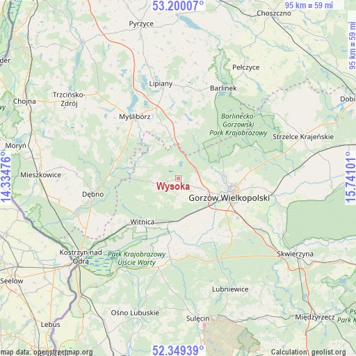
Wysoka GPS coordinates[2]
52° 46' 36.516" North, 15° 2' 16.368" East
| Map corner | latitude | longitude |
|---|---|---|
| Upper-left | 53.20007°, | 14.33476° |
| Center: | 52.77681°, | 15.03788° |
| Lower-right: | 52.34939°, | 15.74101° |
| Map W x H: | 94.6×94.6 km | = 58.8×58.8mi |
| max Lat: | 54.83135° ⇑19.4% North |
| Wysoka: | 52.77681° |
| min Lat: | ⇓80.6% South 49.21328° |
| min Long | Wysoka | max Long |
| 14.20249° | 15.03788° | 24.03723° |
| W 2.2%⇐ | ⇒97.8% E |
Elevation
Elevation of Wysoka is 68 m = 223 ft, and this is 123.4 m = 405 ft below average elevation for this country.
| Max E: |
974 m = 3196 ft | 91.5% |
| Avg. | 191.4 m = 628 ft | |
| Wysoka | 68 m = 223 ft | |
Min E: |
-3 m = -10 ft | 8.5% |
See also: Poland elevation on elevation.city.
Geographical zone
Wysoka is located in North temperate zone (between Tropic of Cancer and the Arctic Circle). Distance of this North polar circle is 1532.9 km =952.5 mi to North.| Distance of | km | miles | from Wysoka |
|---|---|---|---|
| North Pole | 4138.8 | 2571.7 | to North |
| Arctic Circle | 1532.9 | 952.5 | to North |
| Tropic Cancer | 3262.3 | 2027.1 | to South |
| Equator | 5868.2 | 3646.3 | to South |


Nearby cities:
15 places around Wysoka: (largest is in red/bold)
• Baczyna
5.7 km =3.5 mi,  115°
115°
• Bogdaniec
10 km =6.2 mi,  167°
167°
• Deszczno
22.4 km =13.9 mi, 122°
• Dębno
23.3 km =14.5 mi,  259°
259°
• Gorzów Wielkopolski
13.6 km =8.5 mi,  109°
109°
• Gralewo
23.5 km =14.6 mi,  97°
97°
• Jenin
9.8 km =6.1 mi,  155°
155°
• Krzeszyce
21.6 km =13.4 mi,  185°
185°
• Kłodawa
11.9 km =7.4 mi,  85°
85°
• Lubiszyn
6.1 km =3.8 mi,  274°
274°
• Myślibórz
19.9 km =12.4 mi,  325°
325°
• Nowogródek Pomorski
15 km =9.3 mi,  357°
357°
• Trzcinna
11.9 km =7.4 mi,  351°
351°
• Witnica
14.9 km =9.3 mi,  219°
219°
• Łupowo
10 km =6.2 mi,  146°
146°
Sources, notices
• [Note1] Compared only with cities in Poland existing in our database
• [Src1] Map data: © OpenStreetMap contributors (CC-BY-SA)
• [Src2] Other city data from geonames.org with taken over terms of usage.
• [Src3] Geographical zone / Annual Mean Temperature by Robert A. Rohde @ Wikipedia
