Glisno geodata
Glisno (Lubusz) is a populated place; located in Poland in Europe/Warsaw (GMT+2) time zone. With population of 859 people, there are 2759 cities with bigger population in this country. Compared to other cities in Poland, 76% of cities are located further ↓South; 96.7% of cities are located further →East and 78.4% of cities have higher elevation than Glisno. Note1


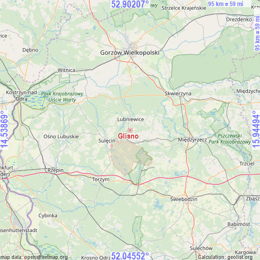
Glisno GPS coordinates[2]
52° 28' 33.168" North, 15° 14' 30.516" East
| Map corner | latitude | longitude |
|---|---|---|
| Upper-left | 52.90207°, | 14.53869° |
| Center: | 52.47588°, | 15.24181° |
| Lower-right: | 52.04552°, | 15.94494° |
| Map W x H: | 95.2×95.2 km | = 59.2×59.2mi |
| max Lat: | 54.83135° ⇑24% North |
| Glisno: | 52.47588° |
| min Lat: | ⇓76% South 49.21328° |
| min Long | Glisno | max Long |
| 14.20249° | 15.24181° | 24.03723° |
| W 3.3%⇐ | ⇒96.7% E |
Elevation
Elevation of Glisno is 103 m = 338 ft, and this is 88.4 m = 290 ft below average elevation for this country.
| Max E: |
974 m = 3196 ft | 78.4% |
| Avg. | 191.4 m = 628 ft | |
| Glisno | 103 m = 338 ft | |
Min E: |
-3 m = -10 ft | 21.6% |
See also: Poland elevation on elevation.city.
Geographical zone
Glisno is located in North temperate zone (between Tropic of Cancer and the Arctic Circle). Distance of this North polar circle is 1566.4 km =973.3 mi to North.| Distance of | km | miles | from Glisno |
|---|---|---|---|
| North Pole | 4172.3 | 2592.5 | to North |
| Arctic Circle | 1566.4 | 973.3 | to North |
| Tropic Cancer | 3228.9 | 2006.3 | to South |
| Equator | 5834.8 | 3625.6 | to South |


Nearby cities:
15 places around Glisno: (largest is in red/bold)
• Bledzew
12.5 km =7.8 mi,  68°
68°
• Boczów
26.3 km =16.3 mi,  229°
229°
• Deszczno
22.2 km =13.8 mi,  13°
13°
• Krzeszyce
19.9 km =12.4 mi,  306°
306°
• Lemierzyce
24.3 km =15.1 mi,  294°
294°
• Lubniewice
4.5 km =2.8 mi, 7°
• Lubrza
23.5 km =14.6 mi,  144°
144°
• Międzyrzecz
23 km =14.3 mi,  98°
98°
• Ośno Lubuskie
24.9 km =15.5 mi,  264°
264°
• Sieniawa
15.5 km =9.6 mi, 143°
• Skwierzyna
22.5 km =14 mi,  52°
52°
• Sulęcin
9.2 km =5.7 mi,  247°
247°
• Torzym
21.1 km =13.1 mi,  210°
210°
• Trzebiszewo
20 km =12.4 mi,  32°
32°
• Łagów
16.2 km =10.1 mi,  166°
166°
Sources, notices
• [Note1] Compared only with cities in Poland existing in our database
• [Src1] Map data: © OpenStreetMap contributors (CC-BY-SA)
• [Src2] Other city data from geonames.org with taken over terms of usage.
• [Src3] Geographical zone / Annual Mean Temperature by Robert A. Rohde @ Wikipedia
