Ustka geodata
Ustka (Pomerania) is a seat of a third-order administrative division; located in Poland in Europe/Warsaw (GMT+2) time zone. With population of 16,250 people, there are 308 cities with bigger population in this country. Compared to other cities in Poland, 99% of cities are located further ↓South; 86.6% of cities are located further →East and 99.5% of cities have higher elevation than Ustka. Note1


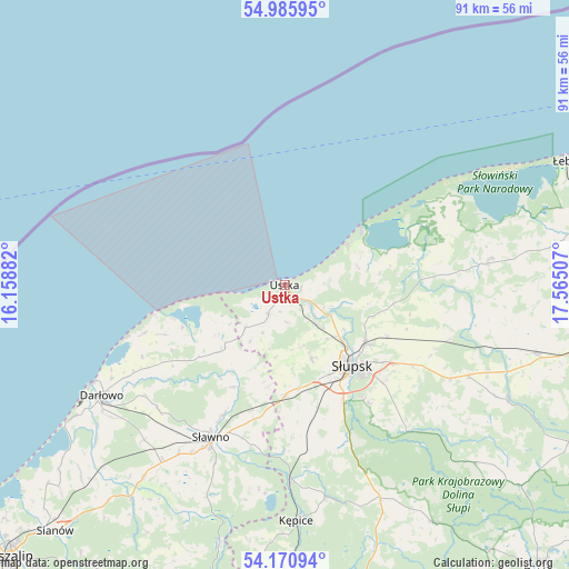
Ustka GPS coordinates[2]
54° 34' 49.728" North, 16° 51' 42.984" East
| Map corner | latitude | longitude |
|---|---|---|
| Upper-left | 54.98595°, | 16.15882° |
| Center: | 54.58048°, | 16.86194° |
| Lower-right: | 54.17094°, | 17.56507° |
| Map W x H: | 90.6×90.6 km | = 56.3×56.3mi |
| max Lat: | 54.83135° ⇑1% North |
| Ustka: | 54.58048° |
| min Lat: | ⇓99% South 49.21328° |
| min Long | Ustka | max Long |
| 14.20249° | 16.86194° | 24.03723° |
| W 13.4%⇐ | ⇒86.6% E |
Elevation
Elevation of Ustka is 2 m = 7 ft, and this is 189.4 m = 621 ft below average elevation for this country.
| Max E: |
974 m = 3196 ft | 99.5% |
| Avg. | 191.4 m = 628 ft | |
| Ustka | 2 m = 7 ft | |
Min E: |
-3 m = -10 ft | 0.5% |
See also: Poland elevation on elevation.city.
Geographical zone
Ustka is located in North temperate zone (between Tropic of Cancer and the Arctic Circle). Distance of this North polar circle is 1332.4 km =827.9 mi to North.| Distance of | km | miles | from Ustka |
|---|---|---|---|
| North Pole | 3938.3 | 2447.1 | to North |
| Arctic Circle | 1332.4 | 827.9 | to North |
| Tropic Cancer | 3462.9 | 2151.7 | to South |
| Equator | 6068.8 | 3771 | to South |


Nearby cities:
15 places around Ustka: (largest is in red/bold)
• Barcino
34.3 km =21.3 mi,  169°
169°
• Bobrowniki
31.2 km =19.4 mi,  101°
101°
• Damnica
27.9 km =17.3 mi,  108°
108°
• Darłowo
34.1 km =21.2 mi,  238°
238°
• Dębnica Kaszubska
29.6 km =18.4 mi,  139°
139°
• Główczyce
33.2 km =20.6 mi,  82°
82°
• Kobylnica
17.9 km =11.1 mi,  150°
150°
• Kępice
37.8 km =23.5 mi,  177°
177°
• Malechowo
37.7 km =23.4 mi,  216°
216°
• Objazda
12.1 km =7.5 mi, 75°
• Ostrowiec
36.1 km =22.4 mi,  200°
200°
• Postomino
13.6 km =8.5 mi, 224°
• Smołdzino
24.4 km =15.2 mi,  67°
67°
• Sławno
26.9 km =16.7 mi,  206°
206°
• Słupsk
16.8 km =10.4 mi, 140°
Sources, notices
• [Note1] Compared only with cities in Poland existing in our database
• [Src1] Map data: © OpenStreetMap contributors (CC-BY-SA)
• [Src2] Other city data from geonames.org with taken over terms of usage.
• [Src3] Geographical zone / Annual Mean Temperature by Robert A. Rohde @ Wikipedia
