Czernica geodata
Czernica (Lower Silesia) is a seat of a third-order administrative division; located in Poland in Europe/Warsaw (GMT+2) time zone. With population of 1,186 people, there are 2228 cities with bigger population in this country. Compared to other cities in Poland, 54% of cities are located further ↑North; 81.8% of cities are located further →East and 67.8% of cities have higher elevation than Czernica. Note1


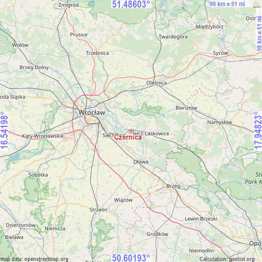
Czernica GPS coordinates[2]
51° 2' 45.924" North, 17° 14' 42.36" East
| Map corner | latitude | longitude |
|---|---|---|
| Upper-left | 51.48603°, | 16.54198° |
| Center: | 51.04609°, | 17.2451° |
| Lower-right: | 50.60193°, | 17.94823° |
| Map W x H: | 98.3×98.3 km | = 61.1×61.1mi |
| max Lat: | 54.83135° ⇑54% North |
| Czernica: | 51.04609° |
| min Lat: | ⇓46% South 49.21328° |
| min Long | Czernica | max Long |
| 14.20249° | 17.2451° | 24.03723° |
| W 18.2%⇐ | ⇒81.8% E |
Elevation
Elevation of Czernica is 126 m = 413 ft, and this is 65.4 m = 215 ft below average elevation for this country.
| Max E: |
974 m = 3196 ft | 67.8% |
| Avg. | 191.4 m = 628 ft | |
| Czernica | 126 m = 413 ft | |
Min E: |
-3 m = -10 ft | 32.2% |
See also: Poland elevation on elevation.city.
Geographical zone
Czernica is located in North temperate zone (between Tropic of Cancer and the Arctic Circle). Distance of this North polar circle is 1725.4 km =1072.1 mi to North.| Distance of | km | miles | from Czernica |
|---|---|---|---|
| North Pole | 4331.3 | 2691.3 | to North |
| Arctic Circle | 1725.4 | 1072.1 | to North |
| Tropic Cancer | 3069.9 | 1907.5 | to South |
| Equator | 5675.8 | 3526.8 | to South |


Nearby cities:
15 places around Czernica: (largest is in red/bold)
• Dobrzykowice
6.5 km =4 mi,  325°
325°
• Gajków
4.3 km =2.7 mi,  290°
290°
• Jelcz
6 km =3.7 mi,  117°
117°
• Jelcz Laskowice
5.7 km =3.5 mi, 118°
• Kamieniec Wrocławski
5.3 km =3.3 mi,  302°
302°
• Księże Małe-Księże Wielkie
11.3 km =7 mi, 285°
• Miłoszyce
4.8 km =3 mi,  85°
85°
• Radwanice
9.5 km =5.9 mi,  275°
275°
• Rakowiec-Opatowice
11 km =6.8 mi, 295°
• Ratowice
2.4 km =1.5 mi,  127°
127°
• Siechnice
7 km =4.3 mi,  258°
258°
• Strachocin-Wojnów
9.3 km =5.8 mi,  314°
314°
• Swojczyce
11.4 km =7.1 mi, 312°
• Wilczyce
11.2 km =7 mi, 325°
• Święta Katarzyna
9.4 km =5.8 mi, 256°
Sources, notices
• [Note1] Compared only with cities in Poland existing in our database
• [Src1] Map data: © OpenStreetMap contributors (CC-BY-SA)
• [Src2] Other city data from geonames.org with taken over terms of usage.
• [Src3] Geographical zone / Annual Mean Temperature by Robert A. Rohde @ Wikipedia
