Radwanice geodata
Radwanice (Lower Silesia) is a populated place; located in Poland in Europe/Warsaw (GMT+2) time zone. With population of 2,446 people, there are 1273 cities with bigger population in this country. Compared to other cities in Poland, 53.8% of cities are located further ↑North; 83.1% of cities are located further →East and 71.1% of cities have higher elevation than Radwanice. Note1


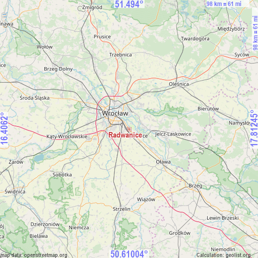
Radwanice GPS coordinates[2]
51° 3' 14.868" North, 17° 6' 33.552" East
| Map corner | latitude | longitude |
|---|---|---|
| Upper-left | 51.494°, | 16.4062° |
| Center: | 51.05413°, | 17.10932° |
| Lower-right: | 50.61004°, | 17.81245° |
| Map W x H: | 98.3×98.3 km | = 61.1×61.1mi |
| max Lat: | 54.83135° ⇑53.8% North |
| Radwanice: | 51.05413° |
| min Lat: | ⇓46.2% South 49.21328° |
| min Long | Radwanice | max Long |
| 14.20249° | 17.10932° | 24.03723° |
| W 16.9%⇐ | ⇒83.1% E |
Elevation
Elevation of Radwanice is 119 m = 390 ft, and this is 72.4 m = 238 ft below average elevation for this country.
| Max E: |
974 m = 3196 ft | 71.1% |
| Avg. | 191.4 m = 628 ft | |
| Radwanice | 119 m = 390 ft | |
Min E: |
-3 m = -10 ft | 28.9% |
See also: Poland elevation on elevation.city.
Geographical zone
Radwanice is located in North temperate zone (between Tropic of Cancer and the Arctic Circle). Distance of this North polar circle is 1724.5 km =1071.6 mi to North.| Distance of | km | miles | from Radwanice |
|---|---|---|---|
| North Pole | 4330.4 | 2690.8 | to North |
| Arctic Circle | 1724.5 | 1071.6 | to North |
| Tropic Cancer | 3070.8 | 1908.1 | to South |
| Equator | 5676.7 | 3527.3 | to South |


Nearby cities:
15 places around Radwanice: (largest is in red/bold)
• Biskupin
5.2 km =3.2 mi,  356°
356°
• Dąbie
6.1 km =3.8 mi,  341°
341°
• Gajków
5.5 km =3.4 mi,  83°
83°
• Kamieniec Wrocławski
5.4 km =3.4 mi,  68°
68°
• Księże Małe-Księże Wielkie
2.5 km =1.6 mi,  325°
325°
• Osiedle Henrykowskie
5.6 km =3.5 mi,  315°
315°
• Partynice
6.8 km =4.2 mi,  283°
283°
• Rakowiec-Opatowice
3.9 km =2.4 mi,  353°
353°
• Rejon ulicy Borowskiej-Południe
6.3 km =3.9 mi,  293°
293°
• Siechnice
3.5 km =2.2 mi,  130°
130°
• Strachocin-Wojnów
6.3 km =3.9 mi,  27°
27°
• Sępolno
6.2 km =3.9 mi, 355°
• Wojszyce
4.5 km =2.8 mi, 275°
• Święta Katarzyna
3.2 km =2 mi,  173°
173°
• Żerniki Wrocławskie
4.4 km =2.7 mi,  237°
237°
Sources, notices
• [Note1] Compared only with cities in Poland existing in our database
• [Src1] Map data: © OpenStreetMap contributors (CC-BY-SA)
• [Src2] Other city data from geonames.org with taken over terms of usage.
• [Src3] Geographical zone / Annual Mean Temperature by Robert A. Rohde @ Wikipedia
