Siechnice geodata
Siechnice (Lower Silesia) is a seat of a third-order administrative division; located in Poland in Europe/Warsaw (GMT+2) time zone. With population of 4,264 people, there are 768 cities with bigger population in this country. Compared to other cities in Poland, 54.4% of cities are located further ↑North; 82.7% of cities are located further →East and 70.4% of cities have higher elevation than Siechnice. Note1


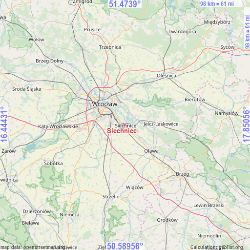
Siechnice GPS coordinates[2]
51° 2' 1.824" North, 17° 8' 50.748" East
| Map corner | latitude | longitude |
|---|---|---|
| Upper-left | 51.4739°, | 16.44431° |
| Center: | 51.03384°, | 17.14743° |
| Lower-right: | 50.58956°, | 17.85056° |
| Map W x H: | 98.3×98.3 km | = 61.1×61.1mi |
| max Lat: | 54.83135° ⇑54.4% North |
| Siechnice: | 51.03384° |
| min Lat: | ⇓45.6% South 49.21328° |
| min Long | Siechnice | max Long |
| 14.20249° | 17.14743° | 24.03723° |
| W 17.3%⇐ | ⇒82.7% E |
Elevation
Elevation of Siechnice is 120 m = 394 ft, and this is 71.4 m = 234 ft below average elevation for this country.
| Max E: |
974 m = 3196 ft | 70.4% |
| Avg. | 191.4 m = 628 ft | |
| Siechnice | 120 m = 394 ft | |
Min E: |
-3 m = -10 ft | 29.6% |
See also: Poland elevation on elevation.city.
Geographical zone
Siechnice is located in North temperate zone (between Tropic of Cancer and the Arctic Circle). Distance of this North polar circle is 1726.7 km =1072.9 mi to North.| Distance of | km | miles | from Siechnice |
|---|---|---|---|
| North Pole | 4332.6 | 2692.2 | to North |
| Arctic Circle | 1726.7 | 1072.9 | to North |
| Tropic Cancer | 3068.5 | 1906.7 | to South |
| Equator | 5674.4 | 3525.9 | to South |


Nearby cities:
15 places around Siechnice: (largest is in red/bold)
• Biskupin
8 km =5 mi,  338°
338°
• Czernica
7 km =4.3 mi,  78°
78°
• Dobrzykowice
7.4 km =4.6 mi,  25°
25°
• Gajków
4 km =2.5 mi,  44°
44°
• Kamieniec Wrocławski
4.9 km =3 mi, 29°
• Księże Małe-Księże Wielkie
6 km =3.7 mi,  316°
316°
• Osiedle Henrykowskie
9.1 km =5.7 mi,  313°
313°
• Radwanice
3.5 km =2.2 mi, 310°
• Rakowiec-Opatowice
6.9 km =4.3 mi,  333°
333°
• Ratowice
8.7 km =5.4 mi,  90°
90°
• Strachocin-Wojnów
7.9 km =4.9 mi,  1°
1°
• Sępolno
9 km =5.6 mi, 339°
• Wojszyce
7.7 km =4.8 mi,  290°
290°
• Święta Katarzyna
2.5 km =1.6 mi,  249°
249°
• Żerniki Wrocławskie
6.4 km =4 mi,  269°
269°
Sources, notices
• [Note1] Compared only with cities in Poland existing in our database
• [Src1] Map data: © OpenStreetMap contributors (CC-BY-SA)
• [Src2] Other city data from geonames.org with taken over terms of usage.
• [Src3] Geographical zone / Annual Mean Temperature by Robert A. Rohde @ Wikipedia
