Ratowice geodata
Ratowice (Lower Silesia) is a populated place; located in Poland in Europe/Warsaw (GMT+2) time zone. With population of 1,100 people, there are 2307 cities with bigger population in this country. Compared to other cities in Poland, 54.4% of cities are located further ↑North; 81.6% of cities are located further →East and 66.4% of cities have higher elevation than Ratowice. Note1


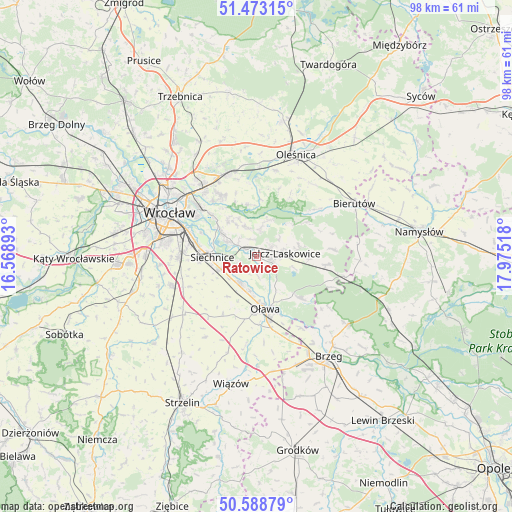
Ratowice GPS coordinates[2]
51° 1' 59.088" North, 17° 16' 19.38" East
| Map corner | latitude | longitude |
|---|---|---|
| Upper-left | 51.47315°, | 16.56893° |
| Center: | 51.03308°, | 17.27205° |
| Lower-right: | 50.58879°, | 17.97518° |
| Map W x H: | 98.3×98.3 km | = 61.1×61.1mi |
| max Lat: | 54.83135° ⇑54.4% North |
| Ratowice: | 51.03308° |
| min Lat: | ⇓45.6% South 49.21328° |
| min Long | Ratowice | max Long |
| 14.20249° | 17.27205° | 24.03723° |
| W 18.4%⇐ | ⇒81.6% E |
Elevation
Elevation of Ratowice is 129 m = 423 ft, and this is 62.4 m = 205 ft below average elevation for this country.
| Max E: |
974 m = 3196 ft | 66.4% |
| Avg. | 191.4 m = 628 ft | |
| Ratowice | 129 m = 423 ft | |
Min E: |
-3 m = -10 ft | 33.6% |
See also: Poland elevation on elevation.city.
Geographical zone
Ratowice is located in North temperate zone (between Tropic of Cancer and the Arctic Circle). Distance of this North polar circle is 1726.8 km =1073 mi to North.| Distance of | km | miles | from Ratowice |
|---|---|---|---|
| North Pole | 4332.7 | 2692.2 | to North |
| Arctic Circle | 1726.8 | 1073 | to North |
| Tropic Cancer | 3068.4 | 1906.6 | to South |
| Equator | 5674.3 | 3525.8 | to South |


Nearby cities:
15 places around Ratowice: (largest is in red/bold)
• Bystrzyca
11.9 km =7.4 mi,  132°
132°
• Czernica
2.4 km =1.5 mi,  307°
307°
• Dobrzykowice
8.7 km =5.4 mi,  320°
320°
• Gajków
6.6 km =4.1 mi,  296°
296°
• Jelcz
3.7 km =2.3 mi,  111°
111°
• Jelcz Laskowice
3.4 km =2.1 mi, 112°
• Kamieniec Wrocławski
7.6 km =4.7 mi, 304°
• Minkowice Oławskie
13.4 km =8.3 mi,  96°
96°
• Miłoszyce
3.4 km =2.1 mi,  56°
56°
• Oława
9.7 km =6 mi,  171°
171°
• Radwanice
11.6 km =7.2 mi,  281°
281°
• Siechnice
8.7 km =5.4 mi,  270°
270°
• Strachocin-Wojnów
11.6 km =7.2 mi, 313°
• Wierzbno
12.5 km =7.8 mi,  211°
211°
• Święta Katarzyna
11 km =6.8 mi, 265°
Sources, notices
• [Note1] Compared only with cities in Poland existing in our database
• [Src1] Map data: © OpenStreetMap contributors (CC-BY-SA)
• [Src2] Other city data from geonames.org with taken over terms of usage.
• [Src3] Geographical zone / Annual Mean Temperature by Robert A. Rohde @ Wikipedia
