Dobrzykowice geodata
Dobrzykowice (Lower Silesia) is a populated place; located in Poland in Europe/Warsaw (GMT+2) time zone. With population of 786 people, there are 2888 cities with bigger population in this country. Compared to other cities in Poland, 52.7% of cities are located further ↑North; 82.2% of cities are located further →East and 70.4% of cities have higher elevation than Dobrzykowice. Note1


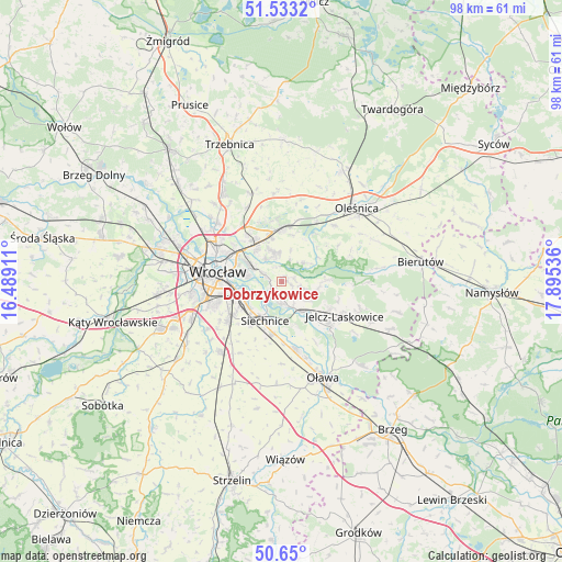
Dobrzykowice GPS coordinates[2]
51° 5' 37.356" North, 17° 11' 32.028" East
| Map corner | latitude | longitude |
|---|---|---|
| Upper-left | 51.5332°, | 16.48911° |
| Center: | 51.09371°, | 17.19223° |
| Lower-right: | 50.65°, | 17.89536° |
| Map W x H: | 98.2×98.2 km | = 61×61mi |
| max Lat: | 54.83135° ⇑52.7% North |
| Dobrzykowice: | 51.09371° |
| min Lat: | ⇓47.3% South 49.21328° |
| min Long | Dobrzykowice | max Long |
| 14.20249° | 17.19223° | 24.03723° |
| W 17.8%⇐ | ⇒82.2% E |
Elevation
Elevation of Dobrzykowice is 120 m = 394 ft, and this is 71.4 m = 234 ft below average elevation for this country.
| Max E: |
974 m = 3196 ft | 70.4% |
| Avg. | 191.4 m = 628 ft | |
| Dobrzykowice | 120 m = 394 ft | |
Min E: |
-3 m = -10 ft | 29.6% |
See also: Poland elevation on elevation.city.
Geographical zone
Dobrzykowice is located in North temperate zone (between Tropic of Cancer and the Arctic Circle). Distance of this North polar circle is 1720.1 km =1068.8 mi to North.| Distance of | km | miles | from Dobrzykowice |
|---|---|---|---|
| North Pole | 4326 | 2688.1 | to North |
| Arctic Circle | 1720.1 | 1068.8 | to North |
| Tropic Cancer | 3075.2 | 1910.8 | to South |
| Equator | 5681.1 | 3530.1 | to South |


Nearby cities:
15 places around Dobrzykowice: (largest is in red/bold)
• Biskupin
6.2 km =3.9 mi,  277°
277°
• Czernica
6.5 km =4 mi,  145°
145°
• Gajków
3.8 km =2.4 mi,  185°
185°
• Kamieniec Wrocławski
2.5 km =1.6 mi,  196°
196°
• Kiełczów
5.2 km =3.2 mi,  349°
349°
• Kowale-Popiele
7.5 km =4.7 mi,  303°
303°
• Psie Pole Południe-Kiełczów
7.5 km =4.7 mi,  323°
323°
• Radwanice
7.3 km =4.5 mi,  232°
232°
• Rakowiec-Opatowice
6.2 km =3.9 mi,  265°
265°
• Siechnice
7.4 km =4.6 mi,  205°
205°
• Strachocin-Wojnów
3.2 km =2 mi,  293°
293°
• Swojczyce
5.3 km =3.3 mi, 297°
• Sępolno
6.6 km =4.1 mi, 285°
• Wilczyce
4.8 km =3 mi,  326°
326°
• Zgorzelisko
6.4 km =4 mi, 320°
Sources, notices
• [Note1] Compared only with cities in Poland existing in our database
• [Src1] Map data: © OpenStreetMap contributors (CC-BY-SA)
• [Src2] Other city data from geonames.org with taken over terms of usage.
• [Src3] Geographical zone / Annual Mean Temperature by Robert A. Rohde @ Wikipedia
