Siemianice geodata
Siemianice (Greater Poland) is a populated place; located in Poland in Europe/Warsaw (GMT+1) time zone. With population of 777 people, there are 2911 cities with bigger population in this country. Compared to other cities in Poland, 50.4% of cities are located further ↓South; 73.6% of cities are located further →East and 55.2% of cities have lower elevation than Siemianice. Note1
Administrative division(s):
- Level 1: Greater Poland
- Level 2: Powiat kępiński
- Level 3: Łęka Opatowska


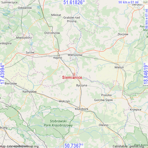
Siemianice GPS coordinates[2]
51° 10' 46.524" North, 18° 8' 35.016" East
| Map corner | latitude | longitude |
|---|---|---|
| Upper-left | 51.61826°, | 17.43994° |
| Center: | 51.17959°, | 18.14306° |
| Lower-right: | 50.7367°, | 18.84619° |
| Map W x H: | 98×98 km | = 60.9×60.9mi |
| max Lat: | 54.83135° ⇑49.6% North |
| Siemianice: | 51.17959° |
| min Lat: | ⇓50.4% South 49.21328° |
| min Long | Siemianice | max Long |
| 14.20249° | 18.14306° | 24.03723° |
| W 26.4%⇐ | ⇒73.6% E |
Elevation
Elevation of Siemianice is 186 m = 610 ft, and this is 5.4 m = 18 ft below average elevation for this country.
| Max E: |
974 m = 3196 ft | 44.8% |
| Avg. | 191.4 m = 628 ft | |
| Siemianice | 186 m = 610 ft | |
Min E: |
-3 m = -10 ft | 55.2% |
See also: Poland elevation on elevation.city.
Geographical zone
Siemianice is located in North temperate zone (between Tropic of Cancer and the Arctic Circle). Distance of this North polar circle is 1710.5 km =1062.9 mi to North.| Distance of | km | miles | from Siemianice |
|---|---|---|---|
| North Pole | 4316.4 | 2682.1 | to North |
| Arctic Circle | 1710.5 | 1062.9 | to North |
| Tropic Cancer | 3084.7 | 1916.7 | to South |
| Equator | 5690.6 | 3536 | to South |


Nearby cities:
15 places around Siemianice: (largest is in red/bold)
• Baranów
13.4 km =8.3 mi,  314°
314°
• Bolesławiec
4 km =2.5 mi,  57°
57°
• Byczyna
8.8 km =5.5 mi,  145°
145°
• Czastary
15.1 km =9.4 mi,  54°
54°
• Dzietrzkowice
12.9 km =8 mi,  100°
100°
• Kępno
15.4 km =9.6 mi,  315°
315°
• Mieleszyn
8.1 km =5 mi,  31°
31°
• Opatów
3.9 km =2.4 mi,  3°
3°
• Skomlin
17 km =10.6 mi,  93°
93°
• Słupia pod Kępnem
9.6 km =6 mi, 313°
• Trzcinica
9.8 km =6.1 mi,  261°
261°
• Wielki Buczek
13.4 km =8.3 mi,  247°
247°
• Wieruszów
12.8 km =8 mi, 3°
• Łubnice
10.4 km =6.5 mi, 99°
• Łęka Opatowska
4.4 km =2.7 mi,  325°
325°
Sources, notices
• [Note1] Compared only with cities in Poland existing in our database
• [Src1] Map data: © OpenStreetMap contributors (CC-BY-SA)
• [Src2] Other city data from geonames.org with taken over terms of usage.
• [Src3] Geographical zone / Annual Mean Temperature by Robert A. Rohde @ Wikipedia
