Chyżne geodata
Chyżne (Lesser Poland) is a populated place; located in Poland in Europe/Warsaw (GMT+2) time zone. With population of 1,069 people, there are 2390 cities with bigger population in this country. Compared to other cities in Poland, 99.4% of cities are located further ↑North; 52.1% of cities are located further ←West and 99.3% of cities have lower elevation than Chyżne. Note1


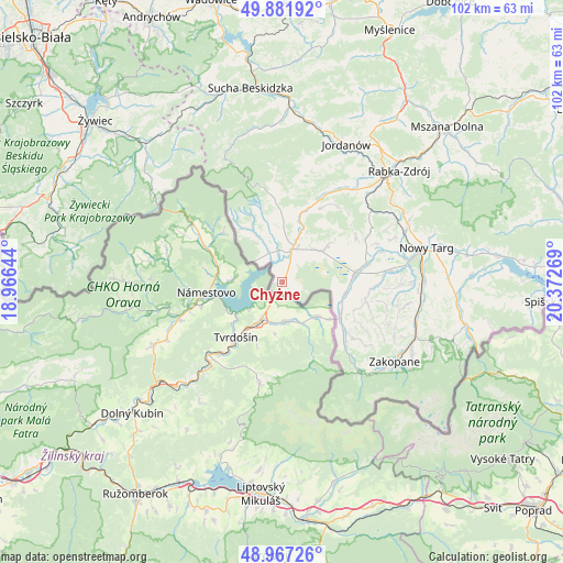
Chyżne GPS coordinates[2]
49° 25' 36.192" North, 19° 40' 10.416" East
| Map corner | latitude | longitude |
|---|---|---|
| Upper-left | 49.88192°, | 18.96644° |
| Center: | 49.42672°, | 19.66956° |
| Lower-right: | 48.96726°, | 20.37269° |
| Map W x H: | 101.7×101.7 km | = 63.2×63.2mi |
| max Lat: | 54.83135° ⇑99.4% North |
| Chyżne: | 49.42672° |
| min Lat: | ⇓0.6% South 49.21328° |
| min Long | Chyżne | max Long |
| 14.20249° | 19.66956° | 24.03723° |
| W 52.1%⇐ | ⇒47.9% E |
Elevation
Elevation of Chyżne is 651 m = 2136 ft, and this is 459.6 m = 1508 ft above average elevation for this country.
| Max E: |
974 m = 3196 ft | 0.7% |
| Chyżne | 651 m 2136 ft | |
| Avg. | 191.4 m = 628 ft | |
Min E: |
-3 m = -10 ft | 99.3% |
See also: Poland elevation on elevation.city.
Geographical zone
Chyżne is located in North temperate zone (between Tropic of Cancer and the Arctic Circle). Distance of this North polar circle is 1905.4 km =1184 mi to North.| Distance of | km | miles | from Chyżne |
|---|---|---|---|
| North Pole | 4511.3 | 2803.2 | to North |
| Arctic Circle | 1905.4 | 1184 | to North |
| Tropic Cancer | 2889.8 | 1795.6 | to South |
| Equator | 5495.7 | 3414.9 | to South |


Nearby cities:
15 places around Chyżne: (largest is in red/bold)
• Czarny Dunajec
13.2 km =8.2 mi,  85°
85°
• Harkabuz
17.2 km =10.7 mi,  44°
44°
• Jabłonka
6.1 km =3.8 mi,  16°
16°
• Lipnica Mała
10.1 km =6.3 mi,  345°
345°
• Lipnica Wielka
5.7 km =3.5 mi,  337°
337°
• Odrowąż
15.4 km =9.6 mi,  59°
59°
• Orawka
10.5 km =6.5 mi, 21°
• Piekielnik
9 km =5.6 mi,  51°
51°
• Pieniążkowice
17.2 km =10.7 mi, 62°
• Podsarnie
16.5 km =10.3 mi,  31°
31°
• Podwilk
14.3 km =8.9 mi, 20°
• Wróblówka
16.1 km =10 mi,  79°
79°
• Załuczne
13 km =8.1 mi, 55°
• Zubrzyca Dolna
11.1 km =6.9 mi,  1°
1°
• Zubrzyca Górna
15.1 km =9.4 mi, 354°
Sources, notices
• [Note1] Compared only with cities in Poland existing in our database
• [Src1] Map data: © OpenStreetMap contributors (CC-BY-SA)
• [Src2] Other city data from geonames.org with taken over terms of usage.
• [Src3] Geographical zone / Annual Mean Temperature by Robert A. Rohde @ Wikipedia
