Ryczywół geodata
Ryczywół (Greater Poland) is a seat of a third-order administrative division; located in Poland in Europe/Warsaw (GMT+2) time zone. With population of 2,000 people, there are 1469 cities with bigger population in this country. Compared to other cities in Poland, 81.1% of cities are located further ↓South; 87% of cities are located further →East and 90.6% of cities have higher elevation than Ryczywół. Note1


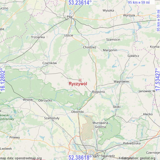
Ryczywół GPS coordinates[2]
52° 48' 47.664" North, 16° 49' 52.104" East
| Map corner | latitude | longitude |
|---|---|---|
| Upper-left | 53.23614°, | 16.12802° |
| Center: | 52.81324°, | 16.83114° |
| Lower-right: | 52.38618°, | 17.53427° |
| Map W x H: | 94.5×94.5 km | = 58.7×58.7mi |
| max Lat: | 54.83135° ⇑18.9% North |
| Ryczywół: | 52.81324° |
| min Lat: | ⇓81.1% South 49.21328° |
| min Long | Ryczywół | max Long |
| 14.20249° | 16.83114° | 24.03723° |
| W 13%⇐ | ⇒87% E |
Elevation
Elevation of Ryczywół is 72 m = 236 ft, and this is 119.4 m = 392 ft below average elevation for this country.
| Max E: |
974 m = 3196 ft | 90.6% |
| Avg. | 191.4 m = 628 ft | |
| Ryczywół | 72 m = 236 ft | |
Min E: |
-3 m = -10 ft | 9.4% |
See also: Poland elevation on elevation.city.
Geographical zone
Ryczywół is located in North temperate zone (between Tropic of Cancer and the Arctic Circle). Distance of this North polar circle is 1528.9 km =950 mi to North.| Distance of | km | miles | from Ryczywół |
|---|---|---|---|
| North Pole | 4134.8 | 2569.2 | to North |
| Arctic Circle | 1528.9 | 950 | to North |
| Tropic Cancer | 3266.4 | 2029.6 | to South |
| Equator | 5872.3 | 3648.9 | to South |


Nearby cities:
15 places around Ryczywół: (largest is in red/bold)
• Budzyń
13.5 km =8.4 mi,  51°
51°
• Chodzież
21.1 km =13.1 mi,  16°
16°
• Czarnków
20.5 km =12.7 mi,  298°
298°
• Lubasz
21.1 km =13.1 mi,  281°
281°
• Margonin
25.1 km =15.6 mi,  44°
44°
• Murowana Goślina
29.1 km =18.1 mi,  155°
155°
• Objezierze
23.7 km =14.7 mi,  191°
191°
• Oborniki
18.5 km =11.5 mi,  183°
183°
• Obrzycko
23.8 km =14.8 mi,  239°
239°
• Połajewo
6.7 km =4.2 mi,  256°
256°
• Rogoźno
12.7 km =7.9 mi,  122°
122°
• Skoki
27.2 km =16.9 mi,  125°
125°
• Szamotuły
28.1 km =17.5 mi,  217°
217°
• Ujście
27.5 km =17.1 mi,  346°
346°
• Wągrowiec
24.8 km =15.4 mi,  91°
91°
Sources, notices
• [Note1] Compared only with cities in Poland existing in our database
• [Src1] Map data: © OpenStreetMap contributors (CC-BY-SA)
• [Src2] Other city data from geonames.org with taken over terms of usage.
• [Src3] Geographical zone / Annual Mean Temperature by Robert A. Rohde @ Wikipedia
