Karwia geodata
Karwia (Pomerania) is a populated place; located in Poland in Europe/Warsaw (GMT+2) time zone. With population of 931 people, there are 2619 cities with bigger population in this country. Compared to other cities in Poland, 100% of cities are located further ↓South; 72.5% of cities are located further →East and 99.9% of cities have higher elevation than Karwia. Note1


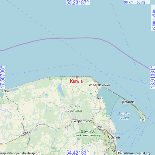
Karwia GPS coordinates[2]
54° 49' 43.968" North, 18° 12' 36.648" East
| Map corner | latitude | longitude |
|---|---|---|
| Upper-left | 55.23187°, | 17.50706° |
| Center: | 54.82888°, | 18.21018° |
| Lower-right: | 54.42183°, | 18.91331° |
| Map W x H: | 90.1×90.1 km | = 56×56mi |
| max Lat: | 54.83135° ⇑0% North |
| Karwia: | 54.82888° |
| min Lat: | ⇓100% South 49.21328° |
| min Long | Karwia | max Long |
| 14.20249° | 18.21018° | 24.03723° |
| W 27.5%⇐ | ⇒72.5% E |
Elevation
Elevation of Karwia is -1 m = -3 ft, and this is 192.4 m = 631 ft below average elevation for this country.
| Max E: |
974 m = 3196 ft | 99.9% |
| Avg. | 191.4 m = 628 ft | |
| Karwia | -1 m = -3 ft | |
Min E: |
-3 m = -10 ft | 0.1% |
See also: Poland elevation on elevation.city.
Geographical zone
Karwia is located in North temperate zone (between Tropic of Cancer and the Arctic Circle). Distance of this North polar circle is 1304.8 km =810.8 mi to North.| Distance of | km | miles | from Karwia |
|---|---|---|---|
| North Pole | 3910.7 | 2430 | to North |
| Arctic Circle | 1304.8 | 810.8 | to North |
| Tropic Cancer | 3490.5 | 2168.9 | to South |
| Equator | 6096.4 | 3788.1 | to South |


Nearby cities:
15 places around Karwia: (largest is in red/bold)
• Chłapowo
10.8 km =6.7 mi,  105°
105°
• Gniewino
17.6 km =10.9 mi,  224°
224°
• Gnieżdżewo
14.1 km =8.8 mi,  129°
129°
• Góra
22.7 km =14.1 mi,  195°
195°
• Jastrzębia Góra
6.6 km =4.1 mi,  87°
87°
• Krokowa
6.3 km =3.9 mi,  209°
209°
• Orle
21.1 km =13.1 mi,  186°
186°
• Ostrowo
2.2 km =1.4 mi,  100°
100°
• Puck
17.7 km =11 mi, 134°
• Rybno
18 km =11.2 mi, 206°
• Strzelno
8.8 km =5.5 mi,  123°
123°
• Swarzewo
14.1 km =8.8 mi, 121°
• Wierzchucino
14 km =8.7 mi,  251°
251°
• Władysławowo
12.9 km =8 mi, 109°
• Żelistrzewo
21.4 km =13.3 mi,  141°
141°
Sources, notices
• [Note1] Compared only with cities in Poland existing in our database
• [Src1] Map data: © OpenStreetMap contributors (CC-BY-SA)
• [Src2] Other city data from geonames.org with taken over terms of usage.
• [Src3] Geographical zone / Annual Mean Temperature by Robert A. Rohde @ Wikipedia
