Tokarnia geodata
Tokarnia (Lesser Poland) is a populated place; located in Poland in Europe/Warsaw (GMT+2) time zone. With population of 3,100 people, there are 1018 cities with bigger population in this country. Compared to other cities in Poland, 93.8% of cities are located further ↑North; 56.3% of cities are located further ←West and 95% of cities have lower elevation than Tokarnia. Note1


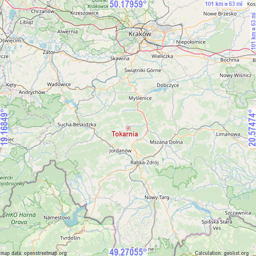
Tokarnia GPS coordinates[2]
49° 43' 37.92" North, 19° 52' 17.796" East
| Map corner | latitude | longitude |
|---|---|---|
| Upper-left | 50.17959°, | 19.16849° |
| Center: | 49.7272°, | 19.87161° |
| Lower-right: | 49.27055°, | 20.57474° |
| Map W x H: | 101.1×101.1 km | = 62.8×62.8mi |
| max Lat: | 54.83135° ⇑93.8% North |
| Tokarnia: | 49.7272° |
| min Lat: | ⇓6.2% South 49.21328° |
| min Long | Tokarnia | max Long |
| 14.20249° | 19.87161° | 24.03723° |
| W 56.3%⇐ | ⇒43.7% E |
Elevation
Elevation of Tokarnia is 417 m = 1368 ft, and this is 225.6 m = 740 ft above average elevation for this country.
| Max E: |
974 m = 3196 ft | 5% |
| Tokarnia | 417 m 1368 ft | |
| Avg. | 191.4 m = 628 ft | |
Min E: |
-3 m = -10 ft | 95% |
See also: Poland elevation on elevation.city.
Geographical zone
Tokarnia is located in North temperate zone (between Tropic of Cancer and the Arctic Circle). Distance of this North polar circle is 1872 km =1163.2 mi to North.| Distance of | km | miles | from Tokarnia |
|---|---|---|---|
| North Pole | 4477.9 | 2782.4 | to North |
| Arctic Circle | 1872 | 1163.2 | to North |
| Tropic Cancer | 2923.2 | 1816.4 | to South |
| Equator | 5529.1 | 3435.6 | to South |


Nearby cities:
15 places around Tokarnia: (largest is in red/bold)
• Bieńkówka
9 km =5.6 mi,  307°
307°
• Bystra
11 km =6.8 mi,  216°
216°
• Harbutowice
11.5 km =7.1 mi,  325°
325°
• Jasienica
10.8 km =6.7 mi,  348°
348°
• Jordanów
9.2 km =5.7 mi,  199°
199°
• Krzczonów
3.6 km =2.2 mi,  70°
70°
• Lubień
7.7 km =4.8 mi,  96°
96°
• Naprawa
9 km =5.6 mi,  176°
176°
• Osielec
8.2 km =5.1 mi,  231°
231°
• Pcim
7.6 km =4.7 mi, 69°
• Skomielna Czarna
2.5 km =1.6 mi,  269°
269°
• Stróża
8.5 km =5.3 mi,  26°
26°
• Trzebunia
7.4 km =4.6 mi, 346°
• Wysoka
12.1 km =7.5 mi,  188°
188°
• Łętownia
3.3 km =2.1 mi, 180°
Sources, notices
• [Note1] Compared only with cities in Poland existing in our database
• [Src1] Map data: © OpenStreetMap contributors (CC-BY-SA)
• [Src2] Other city data from geonames.org with taken over terms of usage.
• [Src3] Geographical zone / Annual Mean Temperature by Robert A. Rohde @ Wikipedia
