Kiczyce geodata
Kiczyce (Silesia) is a populated place; located in Poland in Europe/Warsaw (GMT+2) time zone. With population of 983 people, there are 2528 cities with bigger population in this country. Compared to other cities in Poland, 90.8% of cities are located further ↑North; 63.3% of cities are located further →East and 83.2% of cities have lower elevation than Kiczyce. Note1


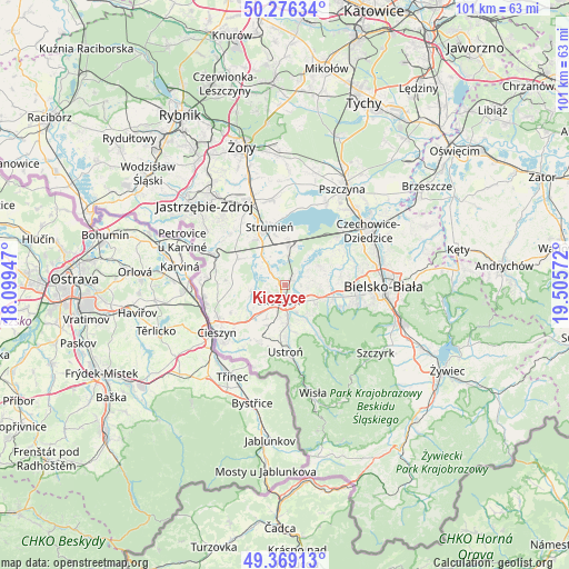
Kiczyce GPS coordinates[2]
49° 49' 29.496" North, 18° 48' 9.324" East
| Map corner | latitude | longitude |
|---|---|---|
| Upper-left | 50.27634°, | 18.09947° |
| Center: | 49.82486°, | 18.80259° |
| Lower-right: | 49.36913°, | 19.50572° |
| Map W x H: | 100.9×100.9 km | = 62.7×62.7mi |
| max Lat: | 54.83135° ⇑90.8% North |
| Kiczyce: | 49.82486° |
| min Lat: | ⇓9.2% South 49.21328° |
| min Long | Kiczyce | max Long |
| 14.20249° | 18.80259° | 24.03723° |
| W 36.7%⇐ | ⇒63.3% E |
Elevation
Elevation of Kiczyce is 281 m = 922 ft, and this is 89.6 m = 294 ft above average elevation for this country.
| Max E: |
974 m = 3196 ft | 16.8% |
| Kiczyce | 281 m 922 ft | |
| Avg. | 191.4 m = 628 ft | |
Min E: |
-3 m = -10 ft | 83.2% |
See also: Poland elevation on elevation.city.
Geographical zone
Kiczyce is located in North temperate zone (between Tropic of Cancer and the Arctic Circle). Distance of this North polar circle is 1861.2 km =1156.5 mi to North.| Distance of | km | miles | from Kiczyce |
|---|---|---|---|
| North Pole | 4467.1 | 2775.7 | to North |
| Arctic Circle | 1861.2 | 1156.5 | to North |
| Tropic Cancer | 2934.1 | 1823.2 | to South |
| Equator | 5540 | 3442.4 | to South |


Nearby cities:
15 places around Kiczyce: (largest is in red/bold)
• Bładnice
5.4 km =3.4 mi,  197°
197°
• Drogomyśl
5.9 km =3.7 mi,  326°
326°
• Dębowiec
6 km =3.7 mi,  258°
258°
• Górki Wielkie
5.4 km =3.4 mi,  157°
157°
• Harbutowice
5.1 km =3.2 mi,  175°
175°
• Iskrzyczyn
5.3 km =3.3 mi,  232°
232°
• Kowale
2.7 km =1.7 mi,  86°
86°
• Miedzyświec
5.3 km =3.3 mi,  211°
211°
• Ochaby
3.1 km =1.9 mi,  309°
309°
• Pierściec
1.3 km =0.8 mi,  41°
41°
• Pogórze
4 km =2.5 mi,  133°
133°
• Simoradz
3.4 km =2.1 mi,  244°
244°
• Skoczów
2.9 km =1.8 mi, 201°
• Wiślica
1.5 km =0.9 mi,  253°
253°
• Zaborze
5.3 km =3.3 mi,  0°
0°
Sources, notices
• [Note1] Compared only with cities in Poland existing in our database
• [Src1] Map data: © OpenStreetMap contributors (CC-BY-SA)
• [Src2] Other city data from geonames.org with taken over terms of usage.
• [Src3] Geographical zone / Annual Mean Temperature by Robert A. Rohde @ Wikipedia
