Wiślica geodata
Wiślica (Silesia) is a populated place; located in Poland in Europe/Warsaw (GMT+2) time zone. With population of 684 people, there are 3101 cities with bigger population in this country. Compared to other cities in Poland, 91% of cities are located further ↑North; 63.6% of cities are located further →East and 91% of cities have lower elevation than Wiślica. Note1


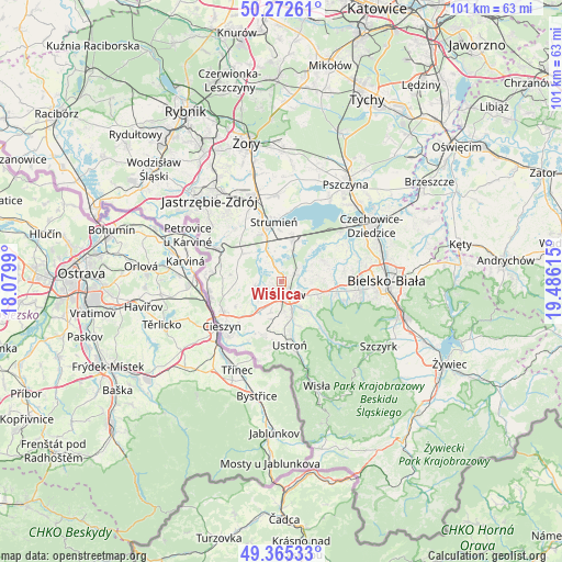
Wiślica GPS coordinates[2]
49° 49' 15.96" North, 18° 46' 58.872" East
| Map corner | latitude | longitude |
|---|---|---|
| Upper-left | 50.27261°, | 18.0799° |
| Center: | 49.8211°, | 18.78302° |
| Lower-right: | 49.36533°, | 19.48615° |
| Map W x H: | 100.9×100.9 km | = 62.7×62.7mi |
| max Lat: | 54.83135° ⇑91% North |
| Wiślica: | 49.8211° |
| min Lat: | ⇓9% South 49.21328° |
| min Long | Wiślica | max Long |
| 14.20249° | 18.78302° | 24.03723° |
| W 36.4%⇐ | ⇒63.6% E |
Elevation
Elevation of Wiślica is 343 m = 1125 ft, and this is 151.6 m = 497 ft above average elevation for this country.
| Max E: |
974 m = 3196 ft | 9% |
| Wiślica | 343 m 1125 ft | |
| Avg. | 191.4 m = 628 ft | |
Min E: |
-3 m = -10 ft | 91% |
See also: Poland elevation on elevation.city.
Geographical zone
Wiślica is located in North temperate zone (between Tropic of Cancer and the Arctic Circle). Distance of this North polar circle is 1861.6 km =1156.7 mi to North.| Distance of | km | miles | from Wiślica |
|---|---|---|---|
| North Pole | 4467.5 | 2776 | to North |
| Arctic Circle | 1861.6 | 1156.7 | to North |
| Tropic Cancer | 2933.7 | 1822.9 | to South |
| Equator | 5539.6 | 3442.1 | to South |


Nearby cities:
15 places around Wiślica: (largest is in red/bold)
• Bładnice
4.7 km =2.9 mi,  183°
183°
• Drogomyśl
5.7 km =3.5 mi,  341°
341°
• Dębowiec
4.5 km =2.8 mi,  260°
260°
• Górki Wielkie
5.8 km =3.6 mi,  143°
143°
• Harbutowice
5 km =3.1 mi,  158°
158°
• Iskrzyczyn
4 km =2.5 mi,  225°
225°
• Kiczyce
1.5 km =0.9 mi,  73°
73°
• Kowale
4.2 km =2.6 mi,  82°
82°
• Miedzyświec
4.3 km =2.7 mi,  197°
197°
• Ochaby
2.6 km =1.6 mi, 337°
• Pierściec
2.6 km =1.6 mi,  58°
58°
• Pogórze
4.9 km =3 mi,  118°
118°
• Simoradz
1.9 km =1.2 mi,  237°
237°
• Skoczów
2.3 km =1.4 mi,  171°
171°
• Zaborze
5.9 km =3.7 mi,  14°
14°
Sources, notices
• [Note1] Compared only with cities in Poland existing in our database
• [Src1] Map data: © OpenStreetMap contributors (CC-BY-SA)
• [Src2] Other city data from geonames.org with taken over terms of usage.
• [Src3] Geographical zone / Annual Mean Temperature by Robert A. Rohde @ Wikipedia
