Łobżenica geodata
Łobżenica (Greater Poland) is a seat of a third-order administrative division; located in Poland in Europe/Warsaw (GMT+2) time zone. With population of 3,211 people, there are 988 cities with bigger population in this country. Compared to other cities in Poland, 87.1% of cities are located further ↓South; 81.7% of cities are located further →East and 77.6% of cities have higher elevation than Łobżenica. Note1


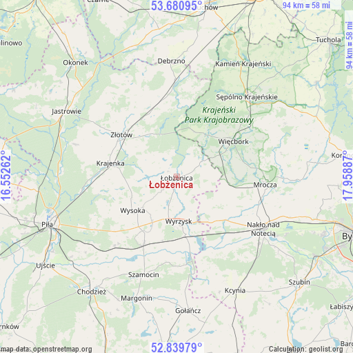
Łobżenica GPS coordinates[2]
53° 15' 44.784" North, 17° 15' 20.664" East
| Map corner | latitude | longitude |
|---|---|---|
| Upper-left | 53.68095°, | 16.55262° |
| Center: | 53.26244°, | 17.25574° |
| Lower-right: | 52.83979°, | 17.95887° |
| Map W x H: | 93.5×93.5 km | = 58.1×58.1mi |
| max Lat: | 54.83135° ⇑12.9% North |
| Łobżenica: | 53.26244° |
| min Lat: | ⇓87.1% South 49.21328° |
| min Long | Łobżenica | max Long |
| 14.20249° | 17.25574° | 24.03723° |
| W 18.3%⇐ | ⇒81.7% E |
Elevation
Elevation of Łobżenica is 104 m = 341 ft, and this is 87.4 m = 287 ft below average elevation for this country.
| Max E: |
974 m = 3196 ft | 77.6% |
| Avg. | 191.4 m = 628 ft | |
| Łobżenica | 104 m = 341 ft | |
Min E: |
-3 m = -10 ft | 22.4% |
See also: Poland elevation on elevation.city.
Geographical zone
Łobżenica is located in North temperate zone (between Tropic of Cancer and the Arctic Circle). Distance of this North polar circle is 1478.9 km =918.9 mi to North.| Distance of | km | miles | from Łobżenica |
|---|---|---|---|
| North Pole | 4084.8 | 2538.2 | to North |
| Arctic Circle | 1478.9 | 918.9 | to North |
| Tropic Cancer | 3316.3 | 2060.7 | to South |
| Equator | 5922.2 | 3679.9 | to South |


Nearby cities:
15 places around Łobżenica: (largest is in red/bold)
• Białośliwie
19.6 km =12.2 mi,  206°
206°
• Krajenka
18 km =11.2 mi,  282°
282°
• Lipka
26 km =16.2 mi,  359°
359°
• Miasteczko Krajeńskie
24.8 km =15.4 mi,  222°
222°
• Mrocza
23.3 km =14.5 mi,  95°
95°
• Nakło nad Notecią
26.6 km =16.5 mi,  120°
120°
• Osiek nad Notecią
16 km =9.9 mi,  171°
171°
• Sadki
17.2 km =10.7 mi,  131°
131°
• Sypniewo
12.8 km =8 mi,  21°
21°
• Więcbork
18.6 km =11.6 mi,  56°
56°
• Wyrzysk
12.2 km =7.6 mi,  176°
176°
• Wysoka
14.6 km =9.1 mi,  231°
231°
• Zakrzewo
17.9 km =11.1 mi,  338°
338°
• Złotów
18.2 km =11.3 mi,  308°
308°
• Śmiłowo
26.3 km =16.3 mi,  237°
237°
Sources, notices
• [Note1] Compared only with cities in Poland existing in our database
• [Src1] Map data: © OpenStreetMap contributors (CC-BY-SA)
• [Src2] Other city data from geonames.org with taken over terms of usage.
• [Src3] Geographical zone / Annual Mean Temperature by Robert A. Rohde @ Wikipedia
