Krajenka geodata
Krajenka (Greater Poland) is a seat of a third-order administrative division; located in Poland in Europe/Warsaw (GMT+2) time zone. With population of 3,609 people, there are 890 cities with bigger population in this country. Compared to other cities in Poland, 87.4% of cities are located further ↓South; 84.9% of cities are located further →East and 78.4% of cities have higher elevation than Krajenka. Note1


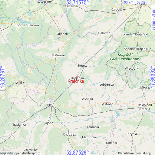
Krajenka GPS coordinates[2]
53° 17' 51.324" North, 16° 59' 26.844" East
| Map corner | latitude | longitude |
|---|---|---|
| Upper-left | 53.71575°, | 16.28767° |
| Center: | 53.29759°, | 16.99079° |
| Lower-right: | 52.87529°, | 17.69392° |
| Map W x H: | 93.5×93.4 km | = 58.1×58mi |
| max Lat: | 54.83135° ⇑12.6% North |
| Krajenka: | 53.29759° |
| min Lat: | ⇓87.4% South 49.21328° |
| min Long | Krajenka | max Long |
| 14.20249° | 16.99079° | 24.03723° |
| W 15.1%⇐ | ⇒84.9% E |
Elevation
Elevation of Krajenka is 103 m = 338 ft, and this is 88.4 m = 290 ft below average elevation for this country.
| Max E: |
974 m = 3196 ft | 78.4% |
| Avg. | 191.4 m = 628 ft | |
| Krajenka | 103 m = 338 ft | |
Min E: |
-3 m = -10 ft | 21.6% |
See also: Poland elevation on elevation.city.
Geographical zone
Krajenka is located in North temperate zone (between Tropic of Cancer and the Arctic Circle). Distance of this North polar circle is 1475 km =916.5 mi to North.| Distance of | km | miles | from Krajenka |
|---|---|---|---|
| North Pole | 4080.9 | 2535.8 | to North |
| Arctic Circle | 1475 | 916.5 | to North |
| Tropic Cancer | 3320.2 | 2063.1 | to South |
| Equator | 5926.1 | 3682.3 | to South |


Nearby cities:
15 places around Krajenka: (largest is in red/bold)
• Białośliwie
23.3 km =14.5 mi,  157°
157°
• Jastrowie
17.9 km =11.1 mi,  319°
319°
• Kaczory
22.8 km =14.2 mi,  198°
198°
• Lipka
28 km =17.4 mi,  38°
38°
• Lędyczek
26.7 km =16.6 mi,  355°
355°
• Miasteczko Krajeńskie
22.2 km =13.8 mi,  177°
177°
• Piła
23.4 km =14.5 mi,  226°
226°
• Sypniewo
23.7 km =14.7 mi,  70°
70°
• Tarnówka
10.4 km =6.5 mi,  298°
298°
• Wyrzysk
24.5 km =15.2 mi,  131°
131°
• Wysoka
14.4 km =8.9 mi,  154°
154°
• Zakrzewo
16.7 km =10.4 mi, 40°
• Złotów
8 km =5 mi,  24°
24°
• Łobżenica
18 km =11.2 mi,  102°
102°
• Śmiłowo
18.5 km =11.5 mi,  194°
194°
Sources, notices
• [Note1] Compared only with cities in Poland existing in our database
• [Src1] Map data: © OpenStreetMap contributors (CC-BY-SA)
• [Src2] Other city data from geonames.org with taken over terms of usage.
• [Src3] Geographical zone / Annual Mean Temperature by Robert A. Rohde @ Wikipedia
