Koluszki geodata
Koluszki (Łódź Voivodeship) is a seat of a third-order administrative division; located in Poland in Europe/Warsaw (GMT+2) time zone. With population of 13,343 people, there are 366 cities with bigger population in this country. Compared to other cities in Poland, 60.9% of cities are located further ↓South; 55.3% of cities are located further ←West and 63.3% of cities have lower elevation than Koluszki. Note1
Administrative division(s):
- Level 1: Łódź Voivodeship
- Level 2: Powiat łódzki wschodni
- Level 3: Koluszki


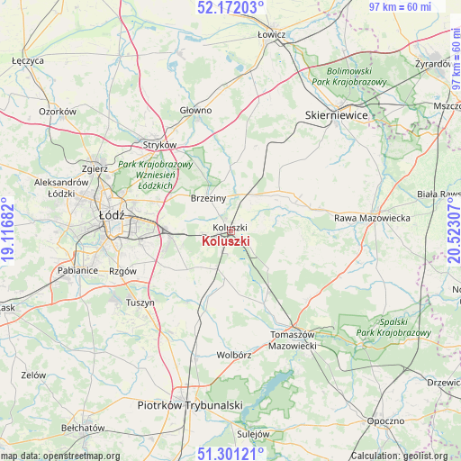
Koluszki GPS coordinates[2]
51° 44' 19.392" North, 19° 49' 11.784" East
| Map corner | latitude | longitude |
|---|---|---|
| Upper-left | 52.17203°, | 19.11682° |
| Center: | 51.73872°, | 19.81994° |
| Lower-right: | 51.30121°, | 20.52307° |
| Map W x H: | 96.8×96.8 km | = 60.1×60.1mi |
| max Lat: | 54.83135° ⇑39.1% North |
| Koluszki: | 51.73872° |
| min Lat: | ⇓60.9% South 49.21328° |
| min Long | Koluszki | max Long |
| 14.20249° | 19.81994° | 24.03723° |
| W 55.3%⇐ | ⇒44.7% E |
Elevation
Elevation of Koluszki is 210 m = 689 ft, and this is 18.6 m = 61 ft above average elevation for this country.
| Max E: |
974 m = 3196 ft | 36.7% |
| Koluszki | 210 m 689 ft | |
| Avg. | 191.4 m = 628 ft | |
Min E: |
-3 m = -10 ft | 63.3% |
See also: Poland elevation on elevation.city.
Geographical zone
Koluszki is located in North temperate zone (between Tropic of Cancer and the Arctic Circle). Distance of this North polar circle is 1648.4 km =1024.3 mi to North.| Distance of | km | miles | from Koluszki |
|---|---|---|---|
| North Pole | 4254.3 | 2643.5 | to North |
| Arctic Circle | 1648.4 | 1024.3 | to North |
| Tropic Cancer | 3146.9 | 1955.4 | to South |
| Equator | 5752.8 | 3574.6 | to South |


Nearby cities:
15 places around Koluszki: (largest is in red/bold)
• Andrespol
12.3 km =7.6 mi,  264°
264°
• Brzeziny
8.3 km =5.2 mi,  325°
325°
• Brójce
14.4 km =8.9 mi,  235°
235°
• Budziszewice
11.3 km =7 mi,  134°
134°
• Będków
17.5 km =10.9 mi,  196°
196°
• Gałków Duży
6.6 km =4.1 mi,  267°
267°
• Gałków Mały
7.5 km =4.7 mi, 258°
• Jeżów
13.2 km =8.2 mi,  50°
50°
• Rogów
9.9 km =6.2 mi,  27°
27°
• Rokiciny
9.9 km =6.2 mi,  187°
187°
• Rokiciny-Kolonia
8.6 km =5.3 mi, 197°
• Słupia
16.6 km =10.3 mi,  38°
38°
• Ujazd
17.2 km =10.7 mi,  155°
155°
• Wola Rakowa
16.1 km =10 mi, 243°
• Żelechlinek
15.1 km =9.4 mi,  101°
101°
Sources, notices
• [Note1] Compared only with cities in Poland existing in our database
• [Src1] Map data: © OpenStreetMap contributors (CC-BY-SA)
• [Src2] Other city data from geonames.org with taken over terms of usage.
• [Src3] Geographical zone / Annual Mean Temperature by Robert A. Rohde @ Wikipedia
