Andrespol geodata
Andrespol (Łódź Voivodeship) is a seat of a third-order administrative division; located in Poland in Europe/Warsaw (GMT+2) time zone. With population of 3,773 people, there are 861 cities with bigger population in this country. Compared to other cities in Poland, 60.7% of cities are located further ↓South; 51.6% of cities are located further ←West and 64.5% of cities have lower elevation than Andrespol. Note1
Administrative division(s):
- Level 1: Łódź Voivodeship
- Level 2: Powiat łódzki wschodni
- Level 3: gmina Andrespol


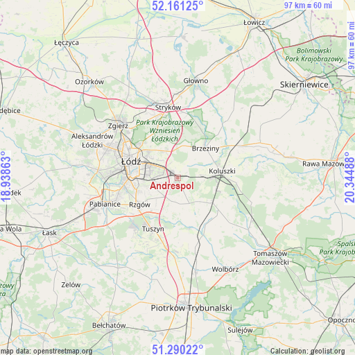
Andrespol GPS coordinates[2]
51° 43' 40.188" North, 19° 38' 30.3" East
| Map corner | latitude | longitude |
|---|---|---|
| Upper-left | 52.16125°, | 18.93863° |
| Center: | 51.72783°, | 19.64175° |
| Lower-right: | 51.29022°, | 20.34488° |
| Map W x H: | 96.8×96.8 km | = 60.1×60.1mi |
| max Lat: | 54.83135° ⇑39.3% North |
| Andrespol: | 51.72783° |
| min Lat: | ⇓60.7% South 49.21328° |
| min Long | Andrespol | max Long |
| 14.20249° | 19.64175° | 24.03723° |
| W 51.6%⇐ | ⇒48.4% E |
Elevation
Elevation of Andrespol is 213 m = 699 ft, and this is 21.6 m = 71 ft above average elevation for this country.
| Max E: |
974 m = 3196 ft | 35.5% |
| Andrespol | 213 m 699 ft | |
| Avg. | 191.4 m = 628 ft | |
Min E: |
-3 m = -10 ft | 64.5% |
See also: Poland elevation on elevation.city.
Geographical zone
Andrespol is located in North temperate zone (between Tropic of Cancer and the Arctic Circle). Distance of this North polar circle is 1649.6 km =1025 mi to North.| Distance of | km | miles | from Andrespol |
|---|---|---|---|
| North Pole | 4255.5 | 2644.2 | to North |
| Arctic Circle | 1649.6 | 1025 | to North |
| Tropic Cancer | 3145.7 | 1954.6 | to South |
| Equator | 5751.6 | 3573.9 | to South |


Nearby cities:
15 places around Andrespol: (largest is in red/bold)
• Brzeziny
11 km =6.8 mi,  43°
43°
• Brójce
7.1 km =4.4 mi,  176°
176°
• Czarnocin
15.4 km =9.6 mi,  169°
169°
• Dobra
16.7 km =10.4 mi,  340°
340°
• Gałków Duży
5.8 km =3.6 mi,  80°
80°
• Gałków Mały
5 km =3.1 mi,  92°
92°
• Koluszki
12.3 km =7.6 mi, 84°
• Ksawerów
17.2 km =10.7 mi,  253°
253°
• Rokiciny
14 km =8.7 mi,  127°
127°
• Rokiciny-Kolonia
12 km =7.5 mi, 125°
• Rzgów
12.6 km =7.8 mi,  235°
235°
• Starowa Góra
11.6 km =7.2 mi, 249°
• Tuszyn
15.2 km =9.4 mi,  210°
210°
• Wola Rakowa
6.4 km =4 mi,  198°
198°
• Łódź
12.5 km =7.8 mi,  292°
292°
Sources, notices
• [Note1] Compared only with cities in Poland existing in our database
• [Src1] Map data: © OpenStreetMap contributors (CC-BY-SA)
• [Src2] Other city data from geonames.org with taken over terms of usage.
• [Src3] Geographical zone / Annual Mean Temperature by Robert A. Rohde @ Wikipedia
