Bełżec geodata
Bełżec (Lublin) is a seat of a third-order administrative division; located in Poland in Europe/Warsaw (GMT+2) time zone. With population of 2,723 people, there are 1153 cities with bigger population in this country. Compared to other cities in Poland, 69.8% of cities are located further ↑North; 98.6% of cities are located further ←West and 79.2% of cities have lower elevation than Bełżec. Note1


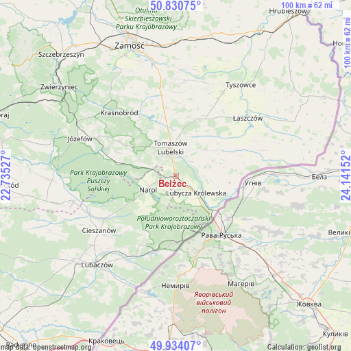
Bełżec GPS coordinates[2]
50° 23' 4.308" North, 23° 26' 18.204" East
| Map corner | latitude | longitude |
|---|---|---|
| Upper-left | 50.83075°, | 22.73527° |
| Center: | 50.38453°, | 23.43839° |
| Lower-right: | 49.93407°, | 24.14152° |
| Map W x H: | 99.7×99.7 km | = 62×62mi |
| max Lat: | 54.83135° ⇑69.8% North |
| Bełżec: | 50.38453° |
| min Lat: | ⇓30.2% South 49.21328° |
| min Long | Bełżec | max Long |
| 14.20249° | 23.43839° | 24.03723° |
| W 98.6%⇐ | ⇒1.4% E |
Elevation
Elevation of Bełżec is 262 m = 860 ft, and this is 70.6 m = 232 ft above average elevation for this country.
| Max E: |
974 m = 3196 ft | 20.8% |
| Bełżec | 262 m 860 ft | |
| Avg. | 191.4 m = 628 ft | |
Min E: |
-3 m = -10 ft | 79.2% |
See also: Poland elevation on elevation.city.
Geographical zone
Bełżec is located in North temperate zone (between Tropic of Cancer and the Arctic Circle). Distance of this North polar circle is 1798.9 km =1117.8 mi to North.| Distance of | km | miles | from Bełżec |
|---|---|---|---|
| North Pole | 4404.8 | 2737 | to North |
| Arctic Circle | 1798.9 | 1117.8 | to North |
| Tropic Cancer | 2996.3 | 1861.8 | to South |
| Equator | 5602.2 | 3481 | to South |


Nearby cities:
15 places around Bełżec: (largest is in red/bold)
• Chotylub
22.2 km =13.8 mi,  222°
222°
• Horyniec-Zdrój
22.1 km =13.7 mi,  194°
194°
• Jarczów
11.3 km =7 mi,  67°
67°
• Krasnobród
24 km =14.9 mi,  318°
318°
• Krynice
22.9 km =14.2 mi,  349°
349°
• Lubycza Królewska
7.5 km =4.7 mi,  130°
130°
• Michałów
21.5 km =13.4 mi,  32°
32°
• Narol
8.8 km =5.5 mi,  243°
243°
• Nowe Brusno
17.7 km =11 mi,  208°
208°
• Oseredek
20.2 km =12.6 mi,  283°
283°
• Rachanie
18.8 km =11.7 mi,  24°
24°
• Rogóźno
9.5 km =5.9 mi,  339°
339°
• Susiec
17.6 km =10.9 mi, 282°
• Tarnawatka
16.6 km =10.3 mi, 349°
• Tomaszów Lubelski
7.2 km =4.5 mi, 347°
Sources, notices
• [Note1] Compared only with cities in Poland existing in our database
• [Src1] Map data: © OpenStreetMap contributors (CC-BY-SA)
• [Src2] Other city data from geonames.org with taken over terms of usage.
• [Src3] Geographical zone / Annual Mean Temperature by Robert A. Rohde @ Wikipedia
