Jarczów geodata
Jarczów (Lublin) is a seat of a third-order administrative division; located in Poland in Europe/Warsaw (GMT+2) time zone. With population of 876 people, there are 2717 cities with bigger population in this country. Compared to other cities in Poland, 69% of cities are located further ↑North; 99.1% of cities are located further ←West and 72.4% of cities have lower elevation than Jarczów. Note1


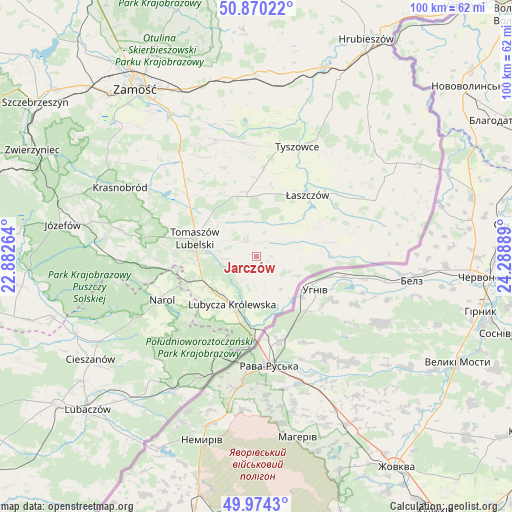
Jarczów GPS coordinates[2]
50° 25' 27.768" North, 23° 35' 8.736" East
| Map corner | latitude | longitude |
|---|---|---|
| Upper-left | 50.87022°, | 22.88264° |
| Center: | 50.42438°, | 23.58576° |
| Lower-right: | 49.9743°, | 24.28889° |
| Map W x H: | 99.6×99.6 km | = 61.9×61.9mi |
| max Lat: | 54.83135° ⇑69% North |
| Jarczów: | 50.42438° |
| min Lat: | ⇓31% South 49.21328° |
| min Long | Jarczów | max Long |
| 14.20249° | 23.58576° | 24.03723° |
| W 99.1%⇐ | ⇒0.90000000000001% E |
Elevation
Elevation of Jarczów is 237 m = 778 ft, and this is 45.6 m = 150 ft above average elevation for this country.
| Max E: |
974 m = 3196 ft | 27.6% |
| Jarczów | 237 m 778 ft | |
| Avg. | 191.4 m = 628 ft | |
Min E: |
-3 m = -10 ft | 72.4% |
See also: Poland elevation on elevation.city.
Geographical zone
Jarczów is located in North temperate zone (between Tropic of Cancer and the Arctic Circle). Distance of this North polar circle is 1794.5 km =1115.1 mi to North.| Distance of | km | miles | from Jarczów |
|---|---|---|---|
| North Pole | 4400.4 | 2734.3 | to North |
| Arctic Circle | 1794.5 | 1115.1 | to North |
| Tropic Cancer | 3000.7 | 1864.5 | to South |
| Equator | 5606.7 | 3483.8 | to South |


Nearby cities:
15 places around Jarczów: (largest is in red/bold)
• Bełżec
11.3 km =7 mi,  247°
247°
• Komarów-Osada
24 km =14.9 mi,  341°
341°
• Krynice
23.2 km =14.4 mi,  321°
321°
• Lubycza Królewska
10.4 km =6.5 mi,  206°
206°
• Michałów
13.7 km =8.5 mi,  5°
5°
• Narol
20.2 km =12.6 mi, 245°
• Nowe Brusno
27.5 km =17.1 mi,  223°
223°
• Rachanie
13 km =8.1 mi,  347°
347°
• Rogóźno
14.5 km =9 mi,  287°
287°
• Tarnawatka
18 km =11.2 mi,  311°
311°
• Telatyn
21.3 km =13.2 mi,  57°
57°
• Tomaszów Lubelski
12.3 km =7.6 mi,  282°
282°
• Tyszowce
22.9 km =14.2 mi,  20°
20°
• Ulhówek
15.4 km =9.6 mi,  79°
79°
• Łaszczów
15.6 km =9.7 mi,  39°
39°
Sources, notices
• [Note1] Compared only with cities in Poland existing in our database
• [Src1] Map data: © OpenStreetMap contributors (CC-BY-SA)
• [Src2] Other city data from geonames.org with taken over terms of usage.
• [Src3] Geographical zone / Annual Mean Temperature by Robert A. Rohde @ Wikipedia
