Lubycza Królewska geodata
Lubycza Królewska (Lublin) is a seat of a third-order administrative division; located in Poland in Europe/Warsaw (GMT+2) time zone. With population of 1,800 people, there are 1605 cities with bigger population in this country. Compared to other cities in Poland, 71% of cities are located further ↑North; 98.8% of cities are located further ←West and 76.5% of cities have lower elevation than Lubycza Królewska. Note1


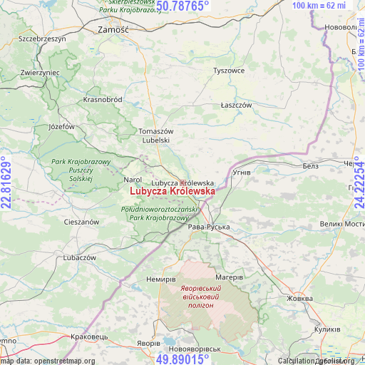
Lubycza Królewska GPS coordinates[2]
50° 20' 27.672" North, 23° 31' 9.876" East
| Map corner | latitude | longitude |
|---|---|---|
| Upper-left | 50.78765°, | 22.81629° |
| Center: | 50.34102°, | 23.51941° |
| Lower-right: | 49.89015°, | 24.22254° |
| Map W x H: | 99.8×99.8 km | = 62×62mi |
| max Lat: | 54.83135° ⇑71% North |
| Lubycza Królewska: | 50.34102° |
| min Lat: | ⇓29% South 49.21328° |
| min Long | Lubycza Królew | max Long |
| 14.20249° | 23.51941° | 24.03723° |
| W 98.8%⇐ | ⇒1.2% E |
Elevation
Elevation of Lubycza Królewska is 252 m = 827 ft, and this is 60.6 m = 199 ft above average elevation for this country.
| Max E: |
974 m = 3196 ft | 23.5% |
| Lubycza Królewska | 252 m 827 ft | |
| Avg. | 191.4 m = 628 ft | |
Min E: |
-3 m = -10 ft | 76.5% |
See also: Poland elevation on elevation.city.
Geographical zone
Lubycza Królewska is located in North temperate zone (between Tropic of Cancer and the Arctic Circle). Distance of this North polar circle is 1803.8 km =1120.8 mi to North.| Distance of | km | miles | from Lubycza Królewska |
|---|---|---|---|
| North Pole | 4409.7 | 2740.1 | to North |
| Arctic Circle | 1803.8 | 1120.8 | to North |
| Tropic Cancer | 2991.5 | 1858.8 | to South |
| Equator | 5597.4 | 3478.1 | to South |


Nearby cities:
15 places around Lubycza Królewska: (largest is in red/bold)
• Bełżec
7.5 km =4.7 mi,  310°
310°
• Chotylub
23.7 km =14.7 mi,  241°
241°
• Horyniec-Zdrój
20 km =12.4 mi,  213°
213°
• Jarczów
10.4 km =6.5 mi,  26°
26°
• Michałów
23.7 km =14.7 mi,  14°
14°
• Narol
13.7 km =8.5 mi,  273°
273°
• Nowe Brusno
17.8 km =11.1 mi,  233°
233°
• Oseredek
27.1 km =16.8 mi,  290°
290°
• Rachanie
22 km =13.7 mi, 5°
• Rogóźno
16.5 km =10.3 mi,  326°
326°
• Susiec
24.5 km =15.2 mi, 290°
• Tarnawatka
22.9 km =14.2 mi,  337°
337°
• Tomaszów Lubelski
13.9 km =8.6 mi, 328°
• Ulhówek
23.2 km =14.4 mi,  58°
58°
• Łaszczów
25.9 km =16.1 mi, 34°
Sources, notices
• [Note1] Compared only with cities in Poland existing in our database
• [Src1] Map data: © OpenStreetMap contributors (CC-BY-SA)
• [Src2] Other city data from geonames.org with taken over terms of usage.
• [Src3] Geographical zone / Annual Mean Temperature by Robert A. Rohde @ Wikipedia
