Godziszów Drugi geodata
Godziszów Drugi (Lublin) is a section of populated place; located in Poland in Europe/Warsaw (GMT+2) time zone. With population of 550 people, there are 3408 cities with bigger population in this country. Compared to other cities in Poland, 61.8% of cities are located further ↑North; 91.7% of cities are located further ←West and 80% of cities have lower elevation than Godziszów Drugi. Note1


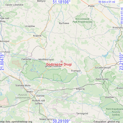
Godziszów Drugi GPS coordinates[2]
50° 44' 17.484" North, 22° 30' 28.44" East
| Map corner | latitude | longitude |
|---|---|---|
| Upper-left | 51.18106°, | 21.80478° |
| Center: | 50.73819°, | 22.5079° |
| Lower-right: | 50.29109°, | 23.21103° |
| Map W x H: | 99×99 km | = 61.5×61.5mi |
| max Lat: | 54.83135° ⇑61.8% North |
| Godziszów Drugi: | 50.73819° |
| min Lat: | ⇓38.2% South 49.21328° |
| min Long | Godziszów Drug | max Long |
| 14.20249° | 22.5079° | 24.03723° |
| W 91.7%⇐ | ⇒8.3% E |
Elevation
Elevation of Godziszów Drugi is 266 m = 873 ft, and this is 74.6 m = 245 ft above average elevation for this country.
| Max E: |
974 m = 3196 ft | 20% |
| Godziszów Drugi | 266 m 873 ft | |
| Avg. | 191.4 m = 628 ft | |
Min E: |
-3 m = -10 ft | 80% |
See also: Poland elevation on elevation.city.
Geographical zone
Godziszów Drugi is located in North temperate zone (between Tropic of Cancer and the Arctic Circle). Distance of this North polar circle is 1759.6 km =1093.4 mi to North.| Distance of | km | miles | from Godziszów Drugi |
|---|---|---|---|
| North Pole | 4365.5 | 2712.6 | to North |
| Arctic Circle | 1759.6 | 1093.4 | to North |
| Tropic Cancer | 3035.6 | 1886.2 | to South |
| Equator | 5641.6 | 3505.5 | to South |


Nearby cities:
15 places around Godziszów Drugi: (largest is in red/bold)
• Batorz
12.5 km =7.8 mi,  355°
355°
• Chrzanów
7.7 km =4.8 mi,  60°
60°
• Dzwola
6.2 km =3.9 mi,  137°
137°
• Frampol
13.6 km =8.5 mi,  122°
122°
• Godziszów
1.4 km =0.9 mi,  329°
329°
• Godziszów Pierwszy
2.7 km =1.7 mi,  321°
321°
• Godziszów Trzeci
0.8 km =0.5 mi,  34°
34°
• Goraj
11.3 km =7 mi,  99°
99°
• Janów Lubelski
7.7 km =4.8 mi,  243°
243°
• Modliborzyce
12.7 km =7.9 mi,  278°
278°
• Potok Wielki
21.3 km =13.2 mi,  286°
286°
• Sułów
21.4 km =13.3 mi, 331°
• Szastarka
18.6 km =11.6 mi,  314°
314°
• Turobin
19 km =11.8 mi, 60°
• Zakrzew
17.9 km =11.1 mi,  19°
19°
Sources, notices
• [Note1] Compared only with cities in Poland existing in our database
• [Src1] Map data: © OpenStreetMap contributors (CC-BY-SA)
• [Src2] Other city data from geonames.org with taken over terms of usage.
• [Src3] Geographical zone / Annual Mean Temperature by Robert A. Rohde @ Wikipedia
