Zakrzew geodata
Zakrzew (Lublin) is a seat of a third-order administrative division; located in Poland in Europe/Warsaw (GMT+2) time zone. With population of 630 people, there are 3202 cities with bigger population in this country. Compared to other cities in Poland, 58% of cities are located further ↑North; 92.6% of cities are located further ←West and 66.7% of cities have lower elevation than Zakrzew. Note1


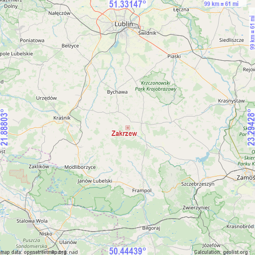
Zakrzew GPS coordinates[2]
50° 53' 24.144" North, 22° 35' 28.14" East
| Map corner | latitude | longitude |
|---|---|---|
| Upper-left | 51.33147°, | 21.88803° |
| Center: | 50.89004°, | 22.59115° |
| Lower-right: | 50.44439°, | 23.29428° |
| Map W x H: | 98.6×98.6 km | = 61.3×61.3mi |
| max Lat: | 54.83135° ⇑58% North |
| Zakrzew: | 50.89004° |
| min Lat: | ⇓42% South 49.21328° |
| min Long | Zakrzew | max Long |
| 14.20249° | 22.59115° | 24.03723° |
| W 92.6%⇐ | ⇒7.4% E |
Elevation
Elevation of Zakrzew is 219 m = 719 ft, and this is 27.6 m = 91 ft above average elevation for this country.
| Max E: |
974 m = 3196 ft | 33.3% |
| Zakrzew | 219 m 719 ft | |
| Avg. | 191.4 m = 628 ft | |
Min E: |
-3 m = -10 ft | 66.7% |
See also: Poland elevation on elevation.city.
Geographical zone
Zakrzew is located in North temperate zone (between Tropic of Cancer and the Arctic Circle). Distance of this North polar circle is 1742.7 km =1082.9 mi to North.| Distance of | km | miles | from Zakrzew |
|---|---|---|---|
| North Pole | 4348.6 | 2702.1 | to North |
| Arctic Circle | 1742.7 | 1082.9 | to North |
| Tropic Cancer | 3052.5 | 1896.7 | to South |
| Equator | 5658.4 | 3516 | to South |


Nearby cities:
15 places around Zakrzew: (largest is in red/bold)
• Batorz
8.2 km =5.1 mi,  237°
237°
• Bychawa
14.6 km =9.1 mi,  343°
343°
• Bystrzyca
16.9 km =10.5 mi,  310°
310°
• Chrzanów
13.1 km =8.1 mi,  176°
176°
• Godziszów
17 km =10.6 mi,  202°
202°
• Godziszów Pierwszy
16.5 km =10.3 mi,  207°
207°
• Godziszów Trzeci
17.1 km =10.6 mi, 198°
• Krzczonów
15.5 km =9.6 mi,  32°
32°
• Rudnik Pierwszy
13.3 km =8.3 mi, 306°
• Sułów
16.3 km =10.1 mi,  276°
276°
• Turobin
12.9 km =8 mi,  124°
124°
• Wysokie
5.7 km =3.5 mi,  66°
66°
• Zakrzówek
16.2 km =10.1 mi,  294°
294°
• Żabno
13.4 km =8.3 mi,  107°
107°
• Żółkiewka
17.2 km =10.7 mi,  82°
82°
Sources, notices
• [Note1] Compared only with cities in Poland existing in our database
• [Src1] Map data: © OpenStreetMap contributors (CC-BY-SA)
• [Src2] Other city data from geonames.org with taken over terms of usage.
• [Src3] Geographical zone / Annual Mean Temperature by Robert A. Rohde @ Wikipedia
