Batorz geodata
Batorz (Lublin) is a seat of a third-order administrative division; located in Poland in Europe/Warsaw (GMT+2) time zone. With population of 982 people, there are 2530 cities with bigger population in this country. Compared to other cities in Poland, 59.1% of cities are located further ↑North; 91.5% of cities are located further ←West and 75.1% of cities have lower elevation than Batorz. Note1


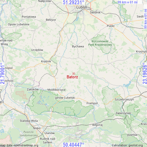
Batorz GPS coordinates[2]
50° 51' 1.8" North, 22° 29' 35.268" East
| Map corner | latitude | longitude |
|---|---|---|
| Upper-left | 51.29231°, | 21.79001° |
| Center: | 50.8505°, | 22.49313° |
| Lower-right: | 50.40447°, | 23.19626° |
| Map W x H: | 98.7×98.7 km | = 61.3×61.3mi |
| max Lat: | 54.83135° ⇑59.1% North |
| Batorz: | 50.8505° |
| min Lat: | ⇓40.9% South 49.21328° |
| min Long | Batorz | max Long |
| 14.20249° | 22.49313° | 24.03723° |
| W 91.5%⇐ | ⇒8.5% E |
Elevation
Elevation of Batorz is 247 m = 810 ft, and this is 55.6 m = 182 ft above average elevation for this country.
| Max E: |
974 m = 3196 ft | 24.9% |
| Batorz | 247 m 810 ft | |
| Avg. | 191.4 m = 628 ft | |
Min E: |
-3 m = -10 ft | 75.1% |
See also: Poland elevation on elevation.city.
Geographical zone
Batorz is located in North temperate zone (between Tropic of Cancer and the Arctic Circle). Distance of this North polar circle is 1747.1 km =1085.6 mi to North.| Distance of | km | miles | from Batorz |
|---|---|---|---|
| North Pole | 4353 | 2704.8 | to North |
| Arctic Circle | 1747.1 | 1085.6 | to North |
| Tropic Cancer | 3048.1 | 1894 | to South |
| Equator | 5654 | 3513.2 | to South |


Nearby cities:
15 places around Batorz: (largest is in red/bold)
• Bystrzyca
16.6 km =10.3 mi,  338°
338°
• Chrzanów
11.6 km =7.2 mi,  138°
138°
• Godziszów
11.3 km =7 mi,  178°
178°
• Godziszów Drugi
12.5 km =7.8 mi, 175°
• Godziszów Pierwszy
10.4 km =6.5 mi, 183°
• Godziszów Trzeci
11.9 km =7.4 mi,  172°
172°
• Janów Lubelski
17 km =10.6 mi,  200°
200°
• Modliborzyce
15.7 km =9.8 mi,  227°
227°
• Rudnik Pierwszy
12.9 km =8 mi, 343°
• Sułów
11.2 km =7 mi,  303°
303°
• Szastarka
12.2 km =7.6 mi,  272°
272°
• Turobin
17.8 km =11.1 mi,  99°
99°
• Wysokie
13.9 km =8.6 mi,  61°
61°
• Zakrzew
8.2 km =5.1 mi, 57°
• Zakrzówek
13.7 km =8.5 mi,  325°
325°
Sources, notices
• [Note1] Compared only with cities in Poland existing in our database
• [Src1] Map data: © OpenStreetMap contributors (CC-BY-SA)
• [Src2] Other city data from geonames.org with taken over terms of usage.
• [Src3] Geographical zone / Annual Mean Temperature by Robert A. Rohde @ Wikipedia
