Sułów geodata
Sułów (Lublin) is a populated place; located in Poland in Europe/Warsaw (GMT+2) time zone. With population of 1,115 people, there are 2288 cities with bigger population in this country. Compared to other cities in Poland, 57.6% of cities are located further ↑North; 89.7% of cities are located further ←West and 71.9% of cities have lower elevation than Sułów. Note1


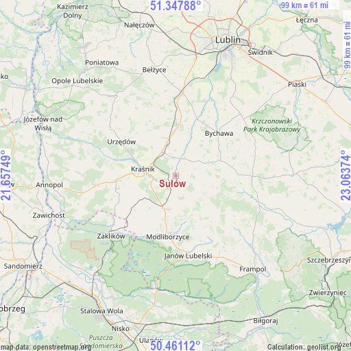
Sułów GPS coordinates[2]
50° 54' 23.796" North, 22° 21' 38.196" East
| Map corner | latitude | longitude |
|---|---|---|
| Upper-left | 51.34788°, | 21.65749° |
| Center: | 50.90661°, | 22.36061° |
| Lower-right: | 50.46112°, | 23.06374° |
| Map W x H: | 98.6×98.6 km | = 61.3×61.3mi |
| max Lat: | 54.83135° ⇑57.6% North |
| Sułów: | 50.90661° |
| min Lat: | ⇓42.4% South 49.21328° |
| min Long | Sułów | max Long |
| 14.20249° | 22.36061° | 24.03723° |
| W 89.7%⇐ | ⇒10.3% E |
Elevation
Elevation of Sułów is 235 m = 771 ft, and this is 43.6 m = 143 ft above average elevation for this country.
| Max E: |
974 m = 3196 ft | 28.1% |
| Sułów | 235 m 771 ft | |
| Avg. | 191.4 m = 628 ft | |
Min E: |
-3 m = -10 ft | 71.9% |
See also: Poland elevation on elevation.city.
Geographical zone
Sułów is located in North temperate zone (between Tropic of Cancer and the Arctic Circle). Distance of this North polar circle is 1740.9 km =1081.7 mi to North.| Distance of | km | miles | from Sułów |
|---|---|---|---|
| North Pole | 4346.8 | 2701 | to North |
| Arctic Circle | 1740.9 | 1081.7 | to North |
| Tropic Cancer | 3054.4 | 1897.9 | to South |
| Equator | 5660.3 | 3517.1 | to South |


Nearby cities:
15 places around Sułów: (largest is in red/bold)
• Batorz
11.2 km =7 mi,  123°
123°
• Bychawa
17.1 km =10.6 mi,  44°
44°
• Bystrzyca
9.8 km =6.1 mi,  19°
19°
• Kraśnik
9.6 km =6 mi,  281°
281°
• Modliborzyce
17.1 km =10.6 mi,  187°
187°
• Potok Wielki
16.3 km =10.1 mi,  218°
218°
• Rudnik Pierwszy
8.2 km =5.1 mi, 42°
• Rzeczyca Ziemiańska
14.2 km =8.8 mi,  240°
240°
• Strzyżowice
16.7 km =10.4 mi, 19°
• Szastarka
6.4 km =4 mi,  206°
206°
• Trzydnik Duży
17.2 km =10.7 mi,  248°
248°
• Urzędów
18.1 km =11.2 mi,  302°
302°
• Wilkołaz
12 km =7.5 mi,  356°
356°
• Zakrzew
16.3 km =10.1 mi,  96°
96°
• Zakrzówek
5.2 km =3.2 mi, 16°
Sources, notices
• [Note1] Compared only with cities in Poland existing in our database
• [Src1] Map data: © OpenStreetMap contributors (CC-BY-SA)
• [Src2] Other city data from geonames.org with taken over terms of usage.
• [Src3] Geographical zone / Annual Mean Temperature by Robert A. Rohde @ Wikipedia
