Godziszów geodata
Godziszów (Lublin) is a seat of a third-order administrative division; located in Poland in Europe/Warsaw (GMT+2) time zone. With population of 2,242 people, there are 1338 cities with bigger population in this country. Compared to other cities in Poland, 61.5% of cities are located further ↑North; 91.5% of cities are located further ←West and 78.8% of cities have lower elevation than Godziszów. Note1


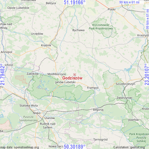
Godziszów GPS coordinates[2]
50° 44' 56.004" North, 22° 29' 52.584" East
| Map corner | latitude | longitude |
|---|---|---|
| Upper-left | 51.19166°, | 21.79482° |
| Center: | 50.74889°, | 22.49794° |
| Lower-right: | 50.30189°, | 23.20107° |
| Map W x H: | 98.9×98.9 km | = 61.5×61.5mi |
| max Lat: | 54.83135° ⇑61.5% North |
| Godziszów: | 50.74889° |
| min Lat: | ⇓38.5% South 49.21328° |
| min Long | Godziszów | max Long |
| 14.20249° | 22.49794° | 24.03723° |
| W 91.5%⇐ | ⇒8.5% E |
Elevation
Elevation of Godziszów is 260 m = 853 ft, and this is 68.6 m = 225 ft above average elevation for this country.
| Max E: |
974 m = 3196 ft | 21.2% |
| Godziszów | 260 m 853 ft | |
| Avg. | 191.4 m = 628 ft | |
Min E: |
-3 m = -10 ft | 78.8% |
See also: Poland elevation on elevation.city.
Geographical zone
Godziszów is located in North temperate zone (between Tropic of Cancer and the Arctic Circle). Distance of this North polar circle is 1758.4 km =1092.6 mi to North.| Distance of | km | miles | from Godziszów |
|---|---|---|---|
| North Pole | 4364.3 | 2711.8 | to North |
| Arctic Circle | 1758.4 | 1092.6 | to North |
| Tropic Cancer | 3036.8 | 1887 | to South |
| Equator | 5642.7 | 3506.2 | to South |


Nearby cities:
15 places around Godziszów: (largest is in red/bold)
• Batorz
11.3 km =7 mi,  358°
358°
• Chrzanów
7.9 km =4.9 mi,  70°
70°
• Dzwola
7.6 km =4.7 mi,  139°
139°
• Frampol
14.9 km =9.3 mi,  125°
125°
• Godziszów Drugi
1.4 km =0.9 mi,  149°
149°
• Godziszów Pierwszy
1.4 km =0.9 mi,  314°
314°
• Godziszów Trzeci
1.3 km =0.8 mi,  112°
112°
• Goraj
12.2 km =7.6 mi,  104°
104°
• Janów Lubelski
7.7 km =4.8 mi,  232°
232°
• Modliborzyce
11.9 km =7.4 mi,  272°
272°
• Potok Wielki
20.4 km =12.7 mi,  283°
283°
• Sułów
20 km =12.4 mi,  331°
331°
• Szastarka
17.2 km =10.7 mi, 313°
• Turobin
19.1 km =11.9 mi,  64°
64°
• Zakrzew
17 km =10.6 mi,  22°
22°
Sources, notices
• [Note1] Compared only with cities in Poland existing in our database
• [Src1] Map data: © OpenStreetMap contributors (CC-BY-SA)
• [Src2] Other city data from geonames.org with taken over terms of usage.
• [Src3] Geographical zone / Annual Mean Temperature by Robert A. Rohde @ Wikipedia
