Zaręby Kościelne geodata
Zaręby Kościelne (Mazovia) is a populated place; located in Poland in Europe/Warsaw (GMT+2) time zone. With population of 660 people, there are 3145 cities with bigger population in this country. Compared to other cities in Poland, 80.3% of cities are located further ↓South; 86.5% of cities are located further ←West and 75.4% of cities have higher elevation than Zaręby Kościelne. Note1


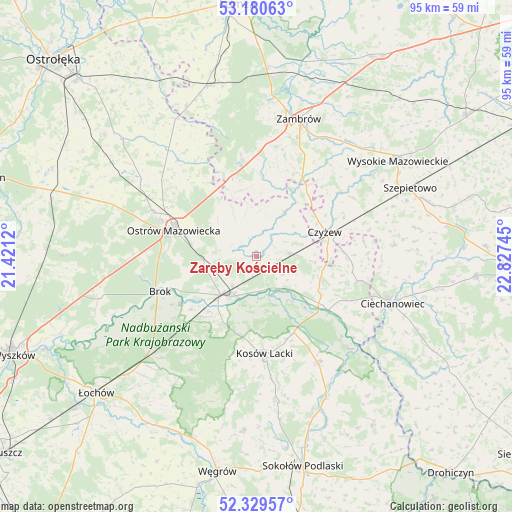
Zaręby Kościelne GPS coordinates[2]
52° 45' 25.848" North, 22° 7' 27.552" East
| Map corner | latitude | longitude |
|---|---|---|
| Upper-left | 53.18063°, | 21.4212° |
| Center: | 52.75718°, | 22.12432° |
| Lower-right: | 52.32957°, | 22.82745° |
| Map W x H: | 94.6×94.6 km | = 58.8×58.8mi |
| max Lat: | 54.83135° ⇑19.7% North |
| Zaręby Kościelne: | 52.75718° |
| min Lat: | ⇓80.3% South 49.21328° |
| min Long | Zaręby Koście | max Long |
| 14.20249° | 22.12432° | 24.03723° |
| W 86.5%⇐ | ⇒13.5% E |
Elevation
Elevation of Zaręby Kościelne is 110 m = 361 ft, and this is 81.4 m = 267 ft below average elevation for this country.
| Max E: |
974 m = 3196 ft | 75.4% |
| Avg. | 191.4 m = 628 ft | |
| Zaręby Kościelne | 110 m = 361 ft | |
Min E: |
-3 m = -10 ft | 24.6% |
See also: Poland elevation on elevation.city.
Geographical zone
Zaręby Kościelne is located in North temperate zone (between Tropic of Cancer and the Arctic Circle). Distance of this North polar circle is 1535.1 km =953.9 mi to North.| Distance of | km | miles | from Zaręby Kościelne |
|---|---|---|---|
| North Pole | 4141 | 2573.1 | to North |
| Arctic Circle | 1535.1 | 953.9 | to North |
| Tropic Cancer | 3260.1 | 2025.7 | to South |
| Equator | 5866 | 3645 | to South |


Nearby cities:
15 places around Zaręby Kościelne: (largest is in red/bold)
• Andrzejewo
9.8 km =6.1 mi,  32°
32°
• Boguty-Pianki
20.1 km =12.5 mi,  102°
102°
• Brok
19.1 km =11.9 mi,  250°
250°
• Ceranów
15.7 km =9.8 mi,  153°
153°
• Ciechanowiec
26.7 km =16.6 mi,  109°
109°
• Czyżew
13.4 km =8.3 mi,  70°
70°
• Klukowo
25.8 km =16 mi,  85°
85°
• Kosów Lacki
18.1 km =11.2 mi,  175°
175°
• Małkinia Górna
9.7 km =6 mi,  221°
221°
• Nur
16.6 km =10.3 mi,  126°
126°
• Ostrów Mazowiecka
16.2 km =10.1 mi,  288°
288°
• Sadowne
22.8 km =14.2 mi,  235°
235°
• Sterdyń
22.7 km =14.1 mi, 149°
• Szumowo
18.2 km =11.3 mi,  351°
351°
• Zambrów
26.6 km =16.5 mi,  17°
17°
Sources, notices
• [Note1] Compared only with cities in Poland existing in our database
• [Src1] Map data: © OpenStreetMap contributors (CC-BY-SA)
• [Src2] Other city data from geonames.org with taken over terms of usage.
• [Src3] Geographical zone / Annual Mean Temperature by Robert A. Rohde @ Wikipedia
