Nur geodata
Nur (Mazovia) is a seat of a third-order administrative division; located in Poland in Europe/Warsaw (GMT+2) time zone. With population of 760 people, there are 2931 cities with bigger population in this country. Compared to other cities in Poland, 78.8% of cities are located further ↓South; 89.3% of cities are located further ←West and 73.1% of cities have higher elevation than Nur. Note1


Nur GPS coordinates[2]
52° 40' 5.736" North, 22° 19' 19.452" East
| Map corner | latitude | longitude |
|---|---|---|
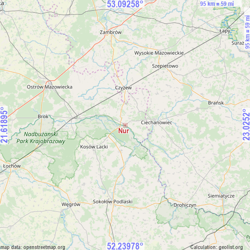
| Upper-left | 53.09258°, | 21.61895° |
| Center: | 52.66826°, | 22.32207° |
| Lower-right: | 52.23978°, | 23.0252° |
| Map W x H: | 94.8×94.8 km | = 58.9×58.9mi |
| max Lat: | 54.83135° ⇑21.2% North |
| Nur: | 52.66826° |
| min Lat: | ⇓78.8% South 49.21328° |
| min Long | Nur | max Long |
| 14.20249° | 22.32207° | 24.03723° |
| W 89.3%⇐ | ⇒10.7% E |
Elevation
Elevation of Nur is 115 m = 377 ft, and this is 76.4 m = 251 ft below average elevation for this country.
| Max E: |
974 m = 3196 ft | 73.1% |
| Avg. | 191.4 m = 628 ft | |
| Nur | 115 m = 377 ft | |
Min E: |
-3 m = -10 ft | 26.9% |
See also: Poland elevation on elevation.city.
Geographical zone
Nur is located in North temperate zone (between Tropic of Cancer and the Arctic Circle). Distance of this North polar circle is 1545 km =960 mi to North.| Distance of | km | miles | from Nur |
|---|---|---|---|
| North Pole | 4150.9 | 2579.2 | to North |
| Arctic Circle | 1545 | 960 | to North |
| Tropic Cancer | 3250.2 | 2019.6 | to South |
| Equator | 5856.2 | 3638.9 | to South |


Nearby cities:
15 places around Nur: (largest is in red/bold)
• Andrzejewo
19.8 km =12.3 mi,  336°
336°
• Boguty-Pianki
8.3 km =5.2 mi,  49°
49°
• Ceranów
7.6 km =4.7 mi,  236°
236°
• Ciechanowiec
11.9 km =7.4 mi,  84°
84°
• Czyżew
14.4 km =8.9 mi,  357°
357°
• Jabłonna Lacka
22.8 km =14.2 mi,  159°
159°
• Klukowo
17.3 km =10.7 mi, 45°
• Kosów Lacki
14.3 km =8.9 mi, 235°
• Małkinia Górna
20 km =12.4 mi,  277°
277°
• Miedzna
27.3 km =17 mi,  215°
215°
• Perlejewo
19.9 km =12.4 mi,  124°
124°
• Sabnie
18.6 km =11.6 mi,  183°
183°
• Sterdyń
10 km =6.2 mi,  191°
191°
• Szepietowo
27 km =16.8 mi,  33°
33°
• Zaręby Kościelne
16.6 km =10.3 mi,  306°
306°
Sources, notices
• [Note1] Compared only with cities in Poland existing in our database
• [Src1] Map data: © OpenStreetMap contributors (CC-BY-SA)
• [Src2] Other city data from geonames.org with taken over terms of usage.
• [Src3] Geographical zone / Annual Mean Temperature by Robert A. Rohde @ Wikipedia
