Brok geodata
Brok (Mazovia) is a populated place; located in Poland in Europe/Warsaw (GMT+2) time zone. With population of 1,896 people, there are 1564 cities with bigger population in this country. Compared to other cities in Poland, 79.2% of cities are located further ↓South; 82.9% of cities are located further ←West and 76.9% of cities have higher elevation than Brok. Note1


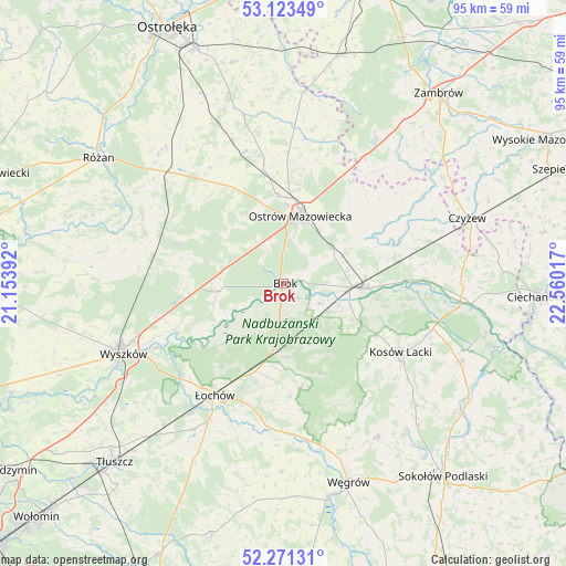
Brok GPS coordinates[2]
52° 41' 58.128" North, 21° 51' 25.344" East
| Map corner | latitude | longitude |
|---|---|---|
| Upper-left | 53.12349°, | 21.15392° |
| Center: | 52.69948°, | 21.85704° |
| Lower-right: | 52.27131°, | 22.56017° |
| Map W x H: | 94.8×94.8 km | = 58.9×58.9mi |
| max Lat: | 54.83135° ⇑20.8% North |
| Brok: | 52.69948° |
| min Lat: | ⇓79.2% South 49.21328° |
| min Long | Brok | max Long |
| 14.20249° | 21.85704° | 24.03723° |
| W 82.9%⇐ | ⇒17.1% E |
Elevation
Elevation of Brok is 106 m = 348 ft, and this is 85.4 m = 280 ft below average elevation for this country.
| Max E: |
974 m = 3196 ft | 76.9% |
| Avg. | 191.4 m = 628 ft | |
| Brok | 106 m = 348 ft | |
Min E: |
-3 m = -10 ft | 23.1% |
See also: Poland elevation on elevation.city.
Geographical zone
Brok is located in North temperate zone (between Tropic of Cancer and the Arctic Circle). Distance of this North polar circle is 1541.5 km =957.8 mi to North.| Distance of | km | miles | from Brok |
|---|---|---|---|
| North Pole | 4147.4 | 2577.1 | to North |
| Arctic Circle | 1541.5 | 957.8 | to North |
| Tropic Cancer | 3253.7 | 2021.8 | to South |
| Equator | 5859.6 | 3641 | to South |


Nearby cities:
15 places around Brok: (largest is in red/bold)
• Andrzejewo
27.5 km =17.1 mi,  57°
57°
• Brańszczyk
19.8 km =12.3 mi,  246°
246°
• Ceranów
26.2 km =16.3 mi,  106°
106°
• Czerwin
28.5 km =17.7 mi,  346°
346°
• Długosiodło
19.1 km =11.9 mi,  290°
290°
• Kosów Lacki
22.7 km =14.1 mi,  120°
120°
• Małkinia Górna
11.6 km =7.2 mi,  94°
94°
• Ostrów Mazowiecka
11.7 km =7.3 mi,  12°
12°
• Ostrówek
17.5 km =10.9 mi,  201°
201°
• Sadowne
6.5 km =4 mi,  186°
186°
• Stoczek
17.6 km =10.9 mi,  170°
170°
• Szumowo
28.8 km =17.9 mi,  32°
32°
• Wąsewo
23 km =14.3 mi,  327°
327°
• Zaręby Kościelne
19.1 km =11.9 mi,  70°
70°
• Łochów
22.2 km =13.8 mi,  212°
212°
Sources, notices
• [Note1] Compared only with cities in Poland existing in our database
• [Src1] Map data: © OpenStreetMap contributors (CC-BY-SA)
• [Src2] Other city data from geonames.org with taken over terms of usage.
• [Src3] Geographical zone / Annual Mean Temperature by Robert A. Rohde @ Wikipedia
