Czyżew geodata
Czyżew (Podlasie) is a seat of a third-order administrative division; located in Poland in Europe/Warsaw (GMT+2) time zone. With population of 2,670 people, there are 1180 cities with bigger population in this country. Compared to other cities in Poland, 80.9% of cities are located further ↓South; 89% of cities are located further ←West and 69.8% of cities have higher elevation than Czyżew. Note1


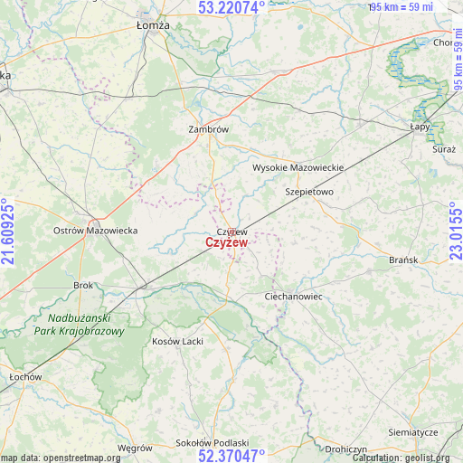
Czyżew GPS coordinates[2]
52° 47' 51.648" North, 22° 18' 44.532" East
| Map corner | latitude | longitude |
|---|---|---|
| Upper-left | 53.22074°, | 21.60925° |
| Center: | 52.79768°, | 22.31237° |
| Lower-right: | 52.37047°, | 23.0155° |
| Map W x H: | 94.5×94.5 km | = 58.7×58.7mi |
| max Lat: | 54.83135° ⇑19.1% North |
| Czyżew: | 52.79768° |
| min Lat: | ⇓80.9% South 49.21328° |
| min Long | Czyżew | max Long |
| 14.20249° | 22.31237° | 24.03723° |
| W 89%⇐ | ⇒11% E |
Elevation
Elevation of Czyżew is 121 m = 397 ft, and this is 70.4 m = 231 ft below average elevation for this country.
| Max E: |
974 m = 3196 ft | 69.8% |
| Avg. | 191.4 m = 628 ft | |
| Czyżew | 121 m = 397 ft | |
Min E: |
-3 m = -10 ft | 30.2% |
See also: Poland elevation on elevation.city.
Geographical zone
Czyżew is located in North temperate zone (between Tropic of Cancer and the Arctic Circle). Distance of this North polar circle is 1530.6 km =951.1 mi to North.| Distance of | km | miles | from Czyżew |
|---|---|---|---|
| North Pole | 4136.5 | 2570.3 | to North |
| Arctic Circle | 1530.6 | 951.1 | to North |
| Tropic Cancer | 3264.6 | 2028.5 | to South |
| Equator | 5870.6 | 3647.8 | to South |


Nearby cities:
15 places around Czyżew: (largest is in red/bold)
• Andrzejewo
8.2 km =5.1 mi,  296°
296°
• Boguty-Pianki
11.4 km =7.1 mi,  142°
142°
• Ceranów
19.4 km =12.1 mi,  196°
196°
• Ciechanowiec
18.2 km =11.3 mi, 136°
• Klukowo
13.3 km =8.3 mi,  100°
100°
• Kosów Lacki
25.1 km =15.6 mi,  206°
206°
• Małkinia Górna
22.4 km =13.9 mi,  238°
238°
• Nur
14.4 km =8.9 mi,  177°
177°
• Ostrów Mazowiecka
28.1 km =17.5 mi,  271°
271°
• Sterdyń
24.2 km =15 mi, 182°
• Szepietowo
17.5 km =10.9 mi,  62°
62°
• Szumowo
20.4 km =12.7 mi,  311°
311°
• Wysokie Mazowieckie
19.1 km =11.9 mi,  46°
46°
• Zambrów
21.4 km =13.3 mi,  347°
347°
• Zaręby Kościelne
13.4 km =8.3 mi,  250°
250°
Sources, notices
• [Note1] Compared only with cities in Poland existing in our database
• [Src1] Map data: © OpenStreetMap contributors (CC-BY-SA)
• [Src2] Other city data from geonames.org with taken over terms of usage.
• [Src3] Geographical zone / Annual Mean Temperature by Robert A. Rohde @ Wikipedia
