Sadowne geodata
Sadowne (Mazovia) is a seat of a third-order administrative division; located in Poland in Europe/Warsaw (GMT+2) time zone. With population of 1,200 people, there are 2164 cities with bigger population in this country. Compared to other cities in Poland, 78.5% of cities are located further ↓South; 82.7% of cities are located further ←West and 81.2% of cities have higher elevation than Sadowne. Note1


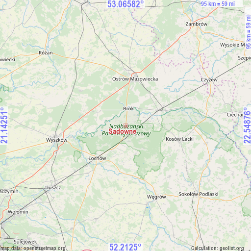
Sadowne GPS coordinates[2]
52° 38' 28.464" North, 21° 50' 44.268" East
| Map corner | latitude | longitude |
|---|---|---|
| Upper-left | 53.06582°, | 21.14251° |
| Center: | 52.64124°, | 21.84563° |
| Lower-right: | 52.2125°, | 22.54876° |
| Map W x H: | 94.9×94.9 km | = 59×59mi |
| max Lat: | 54.83135° ⇑21.5% North |
| Sadowne: | 52.64124° |
| min Lat: | ⇓78.5% South 49.21328° |
| min Long | Sadowne | max Long |
| 14.20249° | 21.84563° | 24.03723° |
| W 82.7%⇐ | ⇒17.3% E |
Elevation
Elevation of Sadowne is 97 m = 318 ft, and this is 94.4 m = 310 ft below average elevation for this country.
| Max E: |
974 m = 3196 ft | 81.2% |
| Avg. | 191.4 m = 628 ft | |
| Sadowne | 97 m = 318 ft | |
Min E: |
-3 m = -10 ft | 18.8% |
See also: Poland elevation on elevation.city.
Geographical zone
Sadowne is located in North temperate zone (between Tropic of Cancer and the Arctic Circle). Distance of this North polar circle is 1548 km =961.9 mi to North.| Distance of | km | miles | from Sadowne |
|---|---|---|---|
| North Pole | 4153.9 | 2581.1 | to North |
| Arctic Circle | 1548 | 961.9 | to North |
| Tropic Cancer | 3247.2 | 2017.7 | to South |
| Equator | 5853.2 | 3637 | to South |


Nearby cities:
15 places around Sadowne: (largest is in red/bold)
• Brańszczyk
17.5 km =10.9 mi,  265°
265°
• Brok
6.5 km =4 mi,  6°
6°
• Ceranów
25.8 km =16 mi,  92°
92°
• Długosiodło
21.6 km =13.4 mi,  307°
307°
• Jadów
23.2 km =14.4 mi,  218°
218°
• Korytnica
25.2 km =15.7 mi,  179°
179°
• Kosów Lacki
21 km =13 mi,  104°
104°
• Małkinia Górna
13.6 km =8.5 mi,  65°
65°
• Miedzna
25.4 km =15.8 mi,  139°
139°
• Ostrów Mazowiecka
18.2 km =11.3 mi, 10°
• Ostrówek
11.3 km =7 mi,  210°
210°
• Stoczek
11.5 km =7.1 mi,  161°
161°
• Wyszków
26.7 km =16.6 mi,  258°
258°
• Zaręby Kościelne
22.8 km =14.2 mi,  55°
55°
• Łochów
16.5 km =10.3 mi, 222°
Sources, notices
• [Note1] Compared only with cities in Poland existing in our database
• [Src1] Map data: © OpenStreetMap contributors (CC-BY-SA)
• [Src2] Other city data from geonames.org with taken over terms of usage.
• [Src3] Geographical zone / Annual Mean Temperature by Robert A. Rohde @ Wikipedia
