Józefów geodata
Józefów (Lublin) is a seat of a third-order administrative division; located in Poland in Europe/Warsaw (GMT+2) time zone. With population of 2,418 people, there are 1279 cities with bigger population in this country. Compared to other cities in Poland, 67.6% of cities are located further ↑North; 96.5% of cities are located further ←West and 75.5% of cities have lower elevation than Józefów. Note1


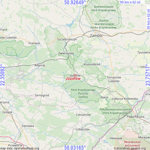
Józefów GPS coordinates[2]
50° 28' 52.284" North, 23° 3' 14.544" East
| Map corner | latitude | longitude |
|---|---|---|
| Upper-left | 50.92649°, | 22.35092° |
| Center: | 50.48119°, | 23.05404° |
| Lower-right: | 50.03165°, | 23.75717° |
| Map W x H: | 99.5×99.5 km | = 61.8×61.8mi |
| max Lat: | 54.83135° ⇑67.6% North |
| Józefów: | 50.48119° |
| min Lat: | ⇓32.4% South 49.21328° |
| min Long | Józefów | max Long |
| 14.20249° | 23.05404° | 24.03723° |
| W 96.5%⇐ | ⇒3.5% E |
Elevation
Elevation of Józefów is 248 m = 814 ft, and this is 56.6 m = 186 ft above average elevation for this country.
| Max E: |
974 m = 3196 ft | 24.5% |
| Józefów | 248 m 814 ft | |
| Avg. | 191.4 m = 628 ft | |
Min E: |
-3 m = -10 ft | 75.5% |
See also: Poland elevation on elevation.city.
Geographical zone
Józefów is located in North temperate zone (between Tropic of Cancer and the Arctic Circle). Distance of this North polar circle is 1788.2 km =1111.1 mi to North.| Distance of | km | miles | from Józefów |
|---|---|---|---|
| North Pole | 4394.1 | 2730.4 | to North |
| Arctic Circle | 1788.2 | 1111.1 | to North |
| Tropic Cancer | 3007.1 | 1868.5 | to South |
| Equator | 5613 | 3487.8 | to South |


Nearby cities:
15 places around Józefów: (largest is in red/bold)
• Aleksandrów
11.6 km =7.2 mi,  261°
261°
• Babice
17.9 km =11.1 mi,  216°
216°
• Kawęczyn
22.8 km =14.2 mi,  340°
340°
• Krasnobród
13.3 km =8.3 mi,  57°
57°
• Księżpol
23.5 km =14.6 mi,  254°
254°
• Narol
24.3 km =15.1 mi,  127°
127°
• Obsza
19.7 km =12.2 mi,  200°
200°
• Oseredek
9.7 km =6 mi, 127°
• Rogóźno
23.9 km =14.9 mi,  94°
94°
• Stanisławów
6.8 km =4.2 mi, 62°
• Susiec
12.2 km =7.6 mi,  124°
124°
• Tereszpol
16.8 km =10.4 mi,  312°
312°
• Zamch
18.3 km =11.4 mi,  185°
185°
• Zwierzyniec
15.8 km =9.8 mi, 339°
• Łukowa
14.2 km =8.8 mi,  213°
213°
Sources, notices
• [Note1] Compared only with cities in Poland existing in our database
• [Src1] Map data: © OpenStreetMap contributors (CC-BY-SA)
• [Src2] Other city data from geonames.org with taken over terms of usage.
• [Src3] Geographical zone / Annual Mean Temperature by Robert A. Rohde @ Wikipedia
