Tarnogród geodata
Tarnogród (Lublin) is a seat of a third-order administrative division; located in Poland in Europe/Warsaw (GMT+2) time zone. With population of 3,396 people, there are 941 cities with bigger population in this country. Compared to other cities in Poland, 70.6% of cities are located further ↑North; 94.1% of cities are located further ←West and 69.8% of cities have lower elevation than Tarnogród. Note1


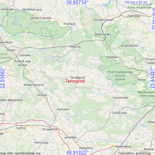
Tarnogród GPS coordinates[2]
50° 21' 39.24" North, 22° 44' 30.264" East
| Map corner | latitude | longitude |
|---|---|---|
| Upper-left | 50.80734°, | 22.03862° |
| Center: | 50.3609°, | 22.74174° |
| Lower-right: | 49.91022°, | 23.44487° |
| Map W x H: | 99.8×99.7 km | = 62×62mi |
| max Lat: | 54.83135° ⇑70.6% North |
| Tarnogród: | 50.3609° |
| min Lat: | ⇓29.4% South 49.21328° |
| min Long | Tarnogród | max Long |
| 14.20249° | 22.74174° | 24.03723° |
| W 94.1%⇐ | ⇒5.9% E |
Elevation
Elevation of Tarnogród is 229 m = 751 ft, and this is 37.6 m = 123 ft above average elevation for this country.
| Max E: |
974 m = 3196 ft | 30.2% |
| Tarnogród | 229 m 751 ft | |
| Avg. | 191.4 m = 628 ft | |
Min E: |
-3 m = -10 ft | 69.8% |
See also: Poland elevation on elevation.city.
Geographical zone
Tarnogród is located in North temperate zone (between Tropic of Cancer and the Arctic Circle). Distance of this North polar circle is 1801.6 km =1119.5 mi to North.| Distance of | km | miles | from Tarnogród |
|---|---|---|---|
| North Pole | 4407.5 | 2738.7 | to North |
| Arctic Circle | 1801.6 | 1119.5 | to North |
| Tropic Cancer | 2993.7 | 1860.2 | to South |
| Equator | 5599.6 | 3479.4 | to South |


Nearby cities:
15 places around Tarnogród: (largest is in red/bold)
• Adamówka
11.8 km =7.3 mi,  195°
195°
• Aleksandrów
15.8 km =9.8 mi,  42°
42°
• Babice
11.4 km =7.1 mi,  94°
94°
• Biszcza
7.9 km =4.9 mi,  304°
304°
• Biłgoraj
20.1 km =12.5 mi,  356°
356°
• Dzików Stary
18.4 km =11.4 mi,  133°
133°
• Księżpol
6.9 km =4.3 mi, 356°
• Kuryłówka
20.7 km =12.9 mi,  250°
250°
• Obsza
16.1 km =10 mi,  108°
108°
• Piskorowice
20.6 km =12.8 mi,  227°
227°
• Potok Górny
13 km =8.1 mi,  281°
281°
• Sieniawa
22.4 km =13.9 mi, 204°
• Wylewa
20.6 km =12.8 mi, 204°
• Zamch
20.9 km =13 mi,  103°
103°
• Łukowa
14.4 km =8.9 mi,  84°
84°
Sources, notices
• [Note1] Compared only with cities in Poland existing in our database
• [Src1] Map data: © OpenStreetMap contributors (CC-BY-SA)
• [Src2] Other city data from geonames.org with taken over terms of usage.
• [Src3] Geographical zone / Annual Mean Temperature by Robert A. Rohde @ Wikipedia
