Aleksandrów geodata
Aleksandrów (Lublin) is a seat of a third-order administrative division; located in Poland in Europe/Warsaw (GMT+2) time zone. With population of 3,135 people, there are 1006 cities with bigger population in this country. Compared to other cities in Poland, 67.9% of cities are located further ↑North; 95.2% of cities are located further ←West and 68.7% of cities have lower elevation than Aleksandrów. Note1


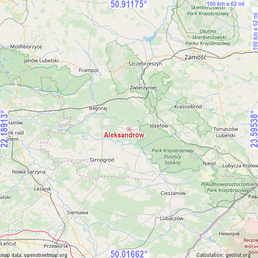
Aleksandrów GPS coordinates[2]
50° 27' 58.68" North, 22° 53' 32.1" East
| Map corner | latitude | longitude |
|---|---|---|
| Upper-left | 50.91175°, | 22.18913° |
| Center: | 50.4663°, | 22.89225° |
| Lower-right: | 50.01662°, | 23.59538° |
| Map W x H: | 99.5×99.5 km | = 61.8×61.8mi |
| max Lat: | 54.83135° ⇑67.9% North |
| Aleksandrów: | 50.4663° |
| min Lat: | ⇓32.1% South 49.21328° |
| min Long | Aleksandrów | max Long |
| 14.20249° | 22.89225° | 24.03723° |
| W 95.2%⇐ | ⇒4.8% E |
Elevation
Elevation of Aleksandrów is 225 m = 738 ft, and this is 33.6 m = 110 ft above average elevation for this country.
| Max E: |
974 m = 3196 ft | 31.3% |
| Aleksandrów | 225 m 738 ft | |
| Avg. | 191.4 m = 628 ft | |
Min E: |
-3 m = -10 ft | 68.7% |
See also: Poland elevation on elevation.city.
Geographical zone
Aleksandrów is located in North temperate zone (between Tropic of Cancer and the Arctic Circle). Distance of this North polar circle is 1789.8 km =1112.1 mi to North.| Distance of | km | miles | from Aleksandrów |
|---|---|---|---|
| North Pole | 4395.7 | 2731.4 | to North |
| Arctic Circle | 1789.8 | 1112.1 | to North |
| Tropic Cancer | 3005.4 | 1867.5 | to South |
| Equator | 5611.3 | 3486.7 | to South |


Nearby cities:
15 places around Aleksandrów: (largest is in red/bold)
• Babice
12.7 km =7.9 mi,  176°
176°
• Biszcza
18.6 km =11.6 mi,  247°
247°
• Biłgoraj
14.6 km =9.1 mi,  304°
304°
• Józefów
11.6 km =7.2 mi,  81°
81°
• Kawęczyn
23.5 km =14.6 mi,  9°
9°
• Księżpol
12.1 km =7.5 mi, 246°
• Obsza
17.4 km =10.8 mi,  164°
164°
• Oseredek
19.6 km =12.2 mi,  102°
102°
• Stanisławów
18.1 km =11.2 mi,  74°
74°
• Susiec
22.1 km =13.7 mi, 103°
• Tarnogród
15.8 km =9.8 mi,  222°
222°
• Tereszpol
13.1 km =8.1 mi,  356°
356°
• Zamch
19.2 km =11.9 mi,  149°
149°
• Zwierzyniec
17.4 km =10.8 mi,  19°
19°
• Łukowa
10.9 km =6.8 mi, 160°
Sources, notices
• [Note1] Compared only with cities in Poland existing in our database
• [Src1] Map data: © OpenStreetMap contributors (CC-BY-SA)
• [Src2] Other city data from geonames.org with taken over terms of usage.
• [Src3] Geographical zone / Annual Mean Temperature by Robert A. Rohde @ Wikipedia
