Zakliczyn geodata
Zakliczyn (Lesser Poland) is a seat of a third-order administrative division; located in Poland in Europe/Warsaw (GMT+2) time zone. With population of 1,534 people, there are 1818 cities with bigger population in this country. Compared to other cities in Poland, 89.6% of cities are located further ↑North; 69.4% of cities are located further ←West and 66.7% of cities have lower elevation than Zakliczyn. Note1


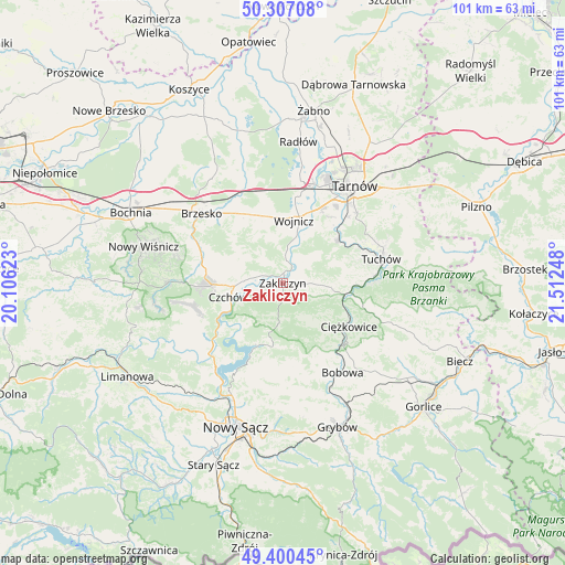
Zakliczyn GPS coordinates[2]
49° 51' 21.204" North, 20° 48' 33.66" East
| Map corner | latitude | longitude |
|---|---|---|
| Upper-left | 50.30708°, | 20.10623° |
| Center: | 49.85589°, | 20.80935° |
| Lower-right: | 49.40045°, | 21.51248° |
| Map W x H: | 100.8×100.8 km | = 62.6×62.6mi |
| max Lat: | 54.83135° ⇑89.6% North |
| Zakliczyn: | 49.85589° |
| min Lat: | ⇓10.4% South 49.21328° |
| min Long | Zakliczyn | max Long |
| 14.20249° | 20.80935° | 24.03723° |
| W 69.4%⇐ | ⇒30.6% E |
Elevation
Elevation of Zakliczyn is 219 m = 719 ft, and this is 27.6 m = 91 ft above average elevation for this country.
| Max E: |
974 m = 3196 ft | 33.3% |
| Zakliczyn | 219 m 719 ft | |
| Avg. | 191.4 m = 628 ft | |
Min E: |
-3 m = -10 ft | 66.7% |
See also: Poland elevation on elevation.city.
Geographical zone
Zakliczyn is located in North temperate zone (between Tropic of Cancer and the Arctic Circle). Distance of this North polar circle is 1857.7 km =1154.3 mi to North.| Distance of | km | miles | from Zakliczyn |
|---|---|---|---|
| North Pole | 4463.6 | 2773.6 | to North |
| Arctic Circle | 1857.7 | 1154.3 | to North |
| Tropic Cancer | 2937.5 | 1825.3 | to South |
| Equator | 5543.5 | 3444.6 | to South |


Nearby cities:
15 places around Zakliczyn: (largest is in red/bold)
• Czchów
9.5 km =5.9 mi,  257°
257°
• Gromnik
11.1 km =6.9 mi,  100°
100°
• Gwoździec
5.4 km =3.4 mi,  318°
318°
• Janowice
5.4 km =3.4 mi,  42°
42°
• Jastrzębia
8.3 km =5.2 mi,  141°
141°
• Jaworsko
7 km =4.3 mi, 322°
• Niedźwiedza
8.1 km =5 mi,  304°
304°
• Olszyny
4.1 km =2.5 mi,  9°
9°
• Rychwałd
10.8 km =6.7 mi,  58°
58°
• Siemiechów
6.9 km =4.3 mi,  92°
92°
• Wielka Wieś
9 km =5.6 mi, 6°
• Wojnicz
11.5 km =7.1 mi, 10°
• Wróblowice
4 km =2.5 mi,  54°
54°
• Złota
8.8 km =5.5 mi,  288°
288°
• Łoniowa
10.7 km =6.6 mi,  309°
309°
Sources, notices
• [Note1] Compared only with cities in Poland existing in our database
• [Src1] Map data: © OpenStreetMap contributors (CC-BY-SA)
• [Src2] Other city data from geonames.org with taken over terms of usage.
• [Src3] Geographical zone / Annual Mean Temperature by Robert A. Rohde @ Wikipedia
