Łukowa geodata
Łukowa (Lesser Poland) is a populated place; located in Poland in Europe/Warsaw (GMT+2) time zone. With population of 1,200 people, there are 2164 cities with bigger population in this country. Compared to other cities in Poland, 78.3% of cities are located further ↑North; 72.2% of cities are located further ←West and 74.5% of cities have lower elevation than Łukowa. Note1


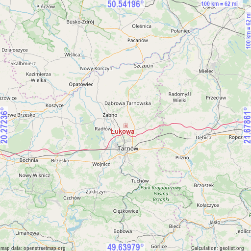
Łukowa GPS coordinates[2]
50° 5' 34.8" North, 20° 58' 31.728" East
| Map corner | latitude | longitude |
|---|---|---|
| Upper-left | 50.54196°, | 20.27236° |
| Center: | 50.093°, | 20.97548° |
| Lower-right: | 49.63979°, | 21.67861° |
| Map W x H: | 100.3×100.3 km | = 62.3×62.3mi |
| max Lat: | 54.83135° ⇑78.3% North |
| Łukowa: | 50.093° |
| min Lat: | ⇓21.7% South 49.21328° |
| min Long | Łukowa | max Long |
| 14.20249° | 20.97548° | 24.03723° |
| W 72.2%⇐ | ⇒27.8% E |
Elevation
Elevation of Łukowa is 244 m = 801 ft, and this is 52.6 m = 173 ft above average elevation for this country.
| Max E: |
974 m = 3196 ft | 25.5% |
| Łukowa | 244 m 801 ft | |
| Avg. | 191.4 m = 628 ft | |
Min E: |
-3 m = -10 ft | 74.5% |
See also: Poland elevation on elevation.city.
Geographical zone
Łukowa is located in North temperate zone (between Tropic of Cancer and the Arctic Circle). Distance of this North polar circle is 1831.4 km =1138 mi to North.| Distance of | km | miles | from Łukowa |
|---|---|---|---|
| North Pole | 4437.2 | 2757.1 | to North |
| Arctic Circle | 1831.4 | 1138 | to North |
| Tropic Cancer | 2963.9 | 1841.7 | to South |
| Equator | 5569.8 | 3460.9 | to South |


Nearby cities:
15 places around Łukowa: (largest is in red/bold)
• Biskupice Radłowskie
8.8 km =5.5 mi,  290°
290°
• Dąbrowa Tarnowska
9.1 km =5.7 mi,  4°
4°
• Gruszów Wielki
11.7 km =7.3 mi,  19°
19°
• Lisia Góra
5.1 km =3.2 mi,  106°
106°
• Nieciecza
11.2 km =7 mi,  306°
306°
• Niedomice
5.9 km =3.7 mi, 285°
• Odporyszów
8 km =5 mi,  325°
325°
• Radłów
9 km =5.6 mi,  263°
263°
• Sieradza
5.7 km =3.5 mi,  324°
324°
• Smyków
12.2 km =7.6 mi,  62°
62°
• Swarzów
11.4 km =7.1 mi,  352°
352°
• Tarnów
8.8 km =5.5 mi,  174°
174°
• Wierzchosławice
11.4 km =7.1 mi,  228°
228°
• Zabawa
11.3 km =7 mi, 285°
• Żabno
7.8 km =4.8 mi, 305°
Sources, notices
• [Note1] Compared only with cities in Poland existing in our database
• [Src1] Map data: © OpenStreetMap contributors (CC-BY-SA)
• [Src2] Other city data from geonames.org with taken over terms of usage.
• [Src3] Geographical zone / Annual Mean Temperature by Robert A. Rohde @ Wikipedia
