Słupno geodata
Słupno (Mazovia) is a populated place; located in Poland in Europe/Warsaw (GMT+2) time zone. With population of 1,500 people, there are 1837 cities with bigger population in this country. Compared to other cities in Poland, 74.4% of cities are located further ↓South; 75.2% of cities are located further ←West and 85.7% of cities have higher elevation than Słupno. Note1


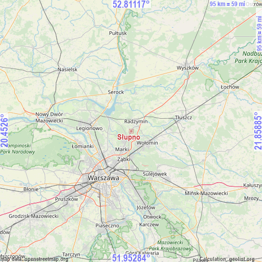
Słupno GPS coordinates[2]
52° 23' 2.724" North, 21° 9' 20.592" East
| Map corner | latitude | longitude |
|---|---|---|
| Upper-left | 52.81117°, | 20.4526° |
| Center: | 52.38409°, | 21.15572° |
| Lower-right: | 51.95284°, | 21.85885° |
| Map W x H: | 95.4×95.4 km | = 59.3×59.3mi |
| max Lat: | 54.83135° ⇑25.6% North |
| Słupno: | 52.38409° |
| min Lat: | ⇓74.4% South 49.21328° |
| min Long | Słupno | max Long |
| 14.20249° | 21.15572° | 24.03723° |
| W 75.2%⇐ | ⇒24.8% E |
Elevation
Elevation of Słupno is 88 m = 289 ft, and this is 103.4 m = 339 ft below average elevation for this country.
| Max E: |
974 m = 3196 ft | 85.7% |
| Avg. | 191.4 m = 628 ft | |
| Słupno | 88 m = 289 ft | |
Min E: |
-3 m = -10 ft | 14.3% |
See also: Poland elevation on elevation.city.
Geographical zone
Słupno is located in North temperate zone (between Tropic of Cancer and the Arctic Circle). Distance of this North polar circle is 1576.6 km =979.7 mi to North.| Distance of | km | miles | from Słupno |
|---|---|---|---|
| North Pole | 4182.5 | 2598.9 | to North |
| Arctic Circle | 1576.6 | 979.7 | to North |
| Tropic Cancer | 3218.6 | 1999.9 | to South |
| Equator | 5824.6 | 3619.2 | to South |


Nearby cities:
15 places around Słupno: (largest is in red/bold)
• Białobrzegi
9.5 km =5.9 mi,  312°
312°
• Czarna
5.1 km =3.2 mi,  110°
110°
• Duczki
9.5 km =5.9 mi,  104°
104°
• Klembów
12.2 km =7.6 mi,  78°
78°
• Kobyłka
5.7 km =3.5 mi,  151°
151°
• Marki
7.9 km =4.9 mi,  206°
206°
• Nieporęt
9.9 km =6.2 mi,  302°
302°
• Nowe Lipiny
8.4 km =5.2 mi, 110°
• Radzymin
4 km =2.5 mi,  28°
28°
• Stanisławów Pierwszy
7.1 km =4.4 mi,  261°
261°
• Stare Grabie
11.2 km =7 mi, 98°
• Targówek
12.6 km =7.8 mi,  215°
215°
• Wołomin
7.6 km =4.7 mi,  129°
129°
• Zielonka
8.9 km =5.5 mi,  178°
178°
• Ząbki
10.7 km =6.6 mi,  198°
198°
Sources, notices
• [Note1] Compared only with cities in Poland existing in our database
• [Src1] Map data: © OpenStreetMap contributors (CC-BY-SA)
• [Src2] Other city data from geonames.org with taken over terms of usage.
• [Src3] Geographical zone / Annual Mean Temperature by Robert A. Rohde @ Wikipedia
